
Quick report
- Aspect
- Northeast
- Red Flags
- Recent Avalanches, Poor Snowpack Structure
- Elevation
- 3200 m
- Red Flags Comment
- <p>The takeaway is that slab avalanches are on the menu in high, northerly, wind-loaded alpine terrain—especially near rocks, and on the leeward sides of ridges. Recent reports of avalanches in the Cottonwoods mostly have been facet-lanches: weak, loose snow moving downhill with no structure. However, this wind-drifted snow avalanche that propagated after likely being triggered by a rider shows us that while these are more the exception than the rule right now, they are possible in just the right, or wrong, places. As we head into this next storm system, keeping events like these on the forefront of the mind will help to dial back early-season powder fever. We've all been waiting for winter to arrive, but I'll be thinking about this snowboarder's experience heading into next week. </p>
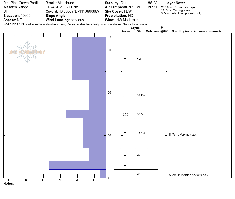
This likely snowboarder-triggered avalanche on a NE aspect near 10,600' was ~13" deep, ~150' wide, and ran about 200 vertical feet. 4-6" of dry, wind-packed snow initially was triggerd and stepped down to the 8-10" of the weak faceted grains that make up the majority of the snowpack in this basin. While there are various, thin melt-freeze crusts mixed in from our warmer periods earlier this month, the snowpack is made up of a majority of FCs of various sizes. A huge thanks to our public observer Christoph who let us know about this avalanche on his hike up the Pfiefferhorn the day prior (see his ob here).
General coverage photos in the Red Pine drainage.
Snowpack
Heading up to the Red Pine drainage, consistent snow coverage started at 8800', with 2-4" of unconsolidated, faceted snow covering the ground in most areas until 9500'. Sun-exposed areas had a thin, eggshell-like melt-freeze crust on the surface below this elevation. Our cold temps have made for some entertaining "ice bulge cruxes", or frozen creek flows, on the trail heading up to Red Pine Lake. As I made my way higher into the Red Pine Basin, past the lower main Red Pine Lake, HS increased to 10-12" on northerly aspects around 10,100', with max HS hitting 18" in spots above 10,300'. The snow surface was a mix of near surface facets in more wind-exposed terrain, with 2-4mm surface hoar remaining in the trees.