
Quick report
- Cracking
- isolated
Toured up to Dan Moller on 3/15 just before the storm arrived. The snowpack appeared generally stable, with the exception of isolated wind pockets on leeward aspects below ridgelines. Snow began falling with cooler temperatures and snowfall intensity increased through the evening. Temperatures then warmed during the early hours of 3/16.
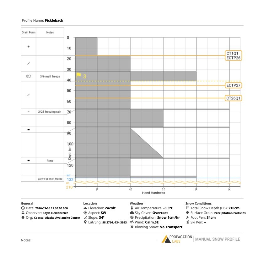
While skiing the next morning, we noticed the new snow was slightly heavier than the day before. We dug a pit and observed moderate to poor structure with propagation 17cm down and 47cm down (right below the 3/6 melt freeze crust) during testing. We took our first lap in mellow terrain where the snow still felt relatively cold and dry. Within an hour, snowfall tapered off and the sun came out. We observed widespread tree shedding, rollerballs, and could feel temperatures rising as solar radiation warmed the snow surface. On our second lap we anticipated the potential for wet loose activity or storm slabs. A snowboarder triggered a D1 storm slab on a SW aspect that entrained wet, slow moving debris. The rider was able to escape easily.
Upon departing the cabin around 2 pm, we observed a couple of natural D1 storm slabs and point release wet loose activity on steeper solar aspects. Avalanche danger appeared to be increasing as we left the zone.
Today felt like a very clear example of how quickly conditions can change hour to hour, and the importance of staying alert to warning signs and seemingly minor changes.
On 3/15 we observed cracking in wind-loaded pockets on leeward slopes just below ridgelines. On 3/16 we observed rollerballs, tree shedding, and a roof avalanche off Dan Moller cabin, along with a handful of natural D1 storm slabs on solar aspects. During the one-hour period between our two laps (12–1 pm), storm slab reactivity increased significantly following 30 minutes of solar radiation.Weather
- Air Temp
- 26
- Cloud Cover
- overcast
- Wind Loading
- light
- Recent Snowfall
- 15
- Snow Avail For Transport
- moderate amounts
Light snowfall started ~1PM on 3/15 and intensified by the evening and through the night. Winds were light - moderate predominantly out of the ESE. Temps warmed overnight and through the morning on 3/16. On 3/16 snowfall was between moderate and heavy until the sun came out around 130PM.
Snowpack
We observed 15cm of new snow since 3/15.
Our snowpit showed approximately 30 cm of soft storm snow overlying the 3/6 pencil-hard melt–freeze crust (9 cm thick). We identified the 2/28 freezing rain crust ~70 cm down, along with two additional ice crusts at 84 cm and 113 cm down. The old snow surface from the late January–early February melt-out was located at approximately 130 cm.
Stability tests showed a reactive storm slab within the new snow, with CT1 @ 10 cm (Q1) and ECTP26 @ 17 cm. We also observed reactivity associated with the 3/6 melt–freeze crust, with ECTP27 @ 45 cm, failing just below the crust. At the time of this pit, we did not observe persistent grains above or below the 3/6 melt–freeze crust.
We dug this pit at 1130 and all the snow appeared to be dry. By the time of our second lap at ~1PM the surface snow was wet and easily made into a snowball.
Avalanche
- Size
- D1 R1
- Type
- WL
- Aspect
- SW
- Trigger
- AR
- Elevation
- 2430 ft
Snowboarder triggered storm slab on a steep rollover on a south westerly facing slope with intense solar radiation.