
Quick report
- Aspect
- West
- Red Flags
- Recent Avalanches, Heavy Snowfall, Wind Loading, Cracking, Collapsing, Poor Snowpack Structure
- Elevation
- 3078 m
- Slope Angle
- 28°
- Red Flags Comment
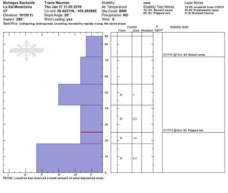
- <p>All kinds of red flags today. On the skin up we would collapse the snowpack in every new area we entered and crack networks would radiate out across entire meadows (up to 100'). This is truly a scary snowpack. We thought we saw a slide in the lower opening of Corkscrew today, but did not have good enough eyes to 100% confirm. We all agreed that it looked like a crown with maybe 95% confidence. Pretty much all of the north face in Dory Canyon over into the pencil shoot coming off of Tukno slide with the Tuesday snow. Looks like it was pretty deep (~2-4') on one of our persistent weak layers.</p>
The wind action on Noreigas ridge
All of Dory Canyon Slide with the Tuesday storm. The crown is most visible on observers left in the pencil shoot, but extents all the way across the open shoots near the upper tree line. This was a big avalanche!
I'm definitely temped to think about extreme for tomorrow if the wind blows like it's supposed to. I'm pretty certain that there will be widespread large dangerous avalanches if we get the snow and wind that are predicted, especially if it's on the high end (up to 25" predicted by NWS).
Snowpack
- Instability Comment
- <p>The primary concern right now is the new dense snow putting new load on the older faceted weak layers. We hadn't looked much a west faces before this, but today we saw that they have the same demons lurking in the old faceted December and October snow that we've been seeing on north aspects. We did see some reactivity in the snow from Tuesday night, but it is only a 15cm packet, and the collapsing a cracking is happening when the porous faceted layers can no longer support the new snow load on top. In our snow pit we had ECT failures at 13 cm below surface (1/15 snow) and down at 60 cm below surface (bottom of Dember snow maybe?). The big worry is triggering this lower faceted weak layer as this could cause a large dangerous avalanche. It is possible that triggering a slide with the new snow could also step down to this deeper layer, but the new snow slab is small enough that I wasn't to worried about it creating a dangerous slide on its own.</p> <p>There was a lot of wind transport today from the south creating new wind slabs and there was probably natural avalanches today as a result. This looks to be a problem through the rest of the pending storm tonight and into tomorrow.</p>
Lots of soft snow to be had in areas less exposed to the wind. Areas with wind exposure varied from punchy crust to hard rime.