
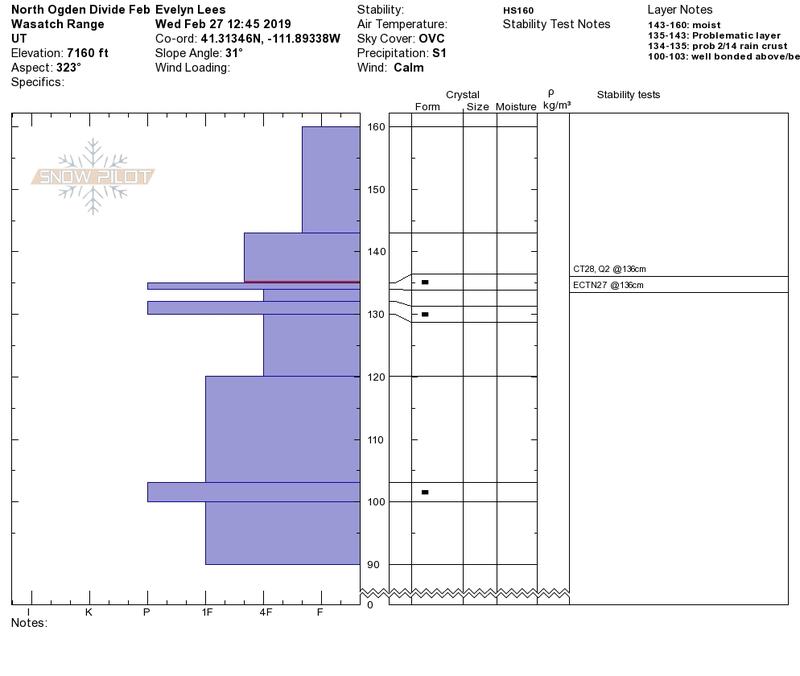
Quick report
- Aspect
- North
- Elevation
- 2195 m
- Slope Angle
- 31°
1st photo is of above profile. While tests in this one spot showed the snow above and below the upper crusts to be fairly strong, these crusts and bonding will vary a lot over short distances with aspect and elevation. It's easy to quickly dig to them, and will be worth doing during and after the next series of storms. Lower pack was strong.
2nd photo - minor cracking of the snow surface, a few inches deep at the moist snow/dry snow transition, mostly above about 7,000'. Hopefully, cooling temperatures overnight and again on Friday will strengthen all the wet mid and low elevation snow. Easily triggered small roller balls at the lower elevations on steep slopes.
1. One of those wet days....with a short lived squall
2. Some surface are wind scored down to the ice crust, and I'd expect poor bonding of the new snow in these places.
3. Even the small, low elevation cornices are/have been sensitive. (6,800', east facing)
Snowpack
Trace to 1/2 inch new snow. Old snow was damp to wet, mashed potatoes, some thin breakable surface crusts, punchy, and a few areas scoured to ice with slide for life potential.