
Quick report
- Aspect
- North
- Red Flags
- Recent Avalanches, Heavy Snowfall, Collapsing, Poor Snowpack Structure
- Elevation
- 2469 m
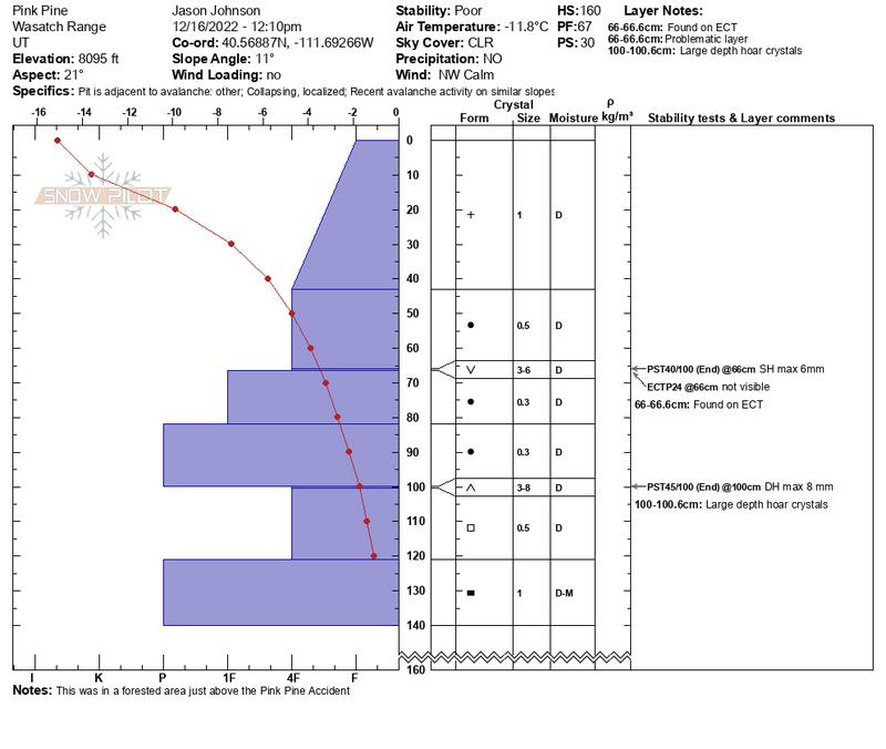
Avy Pro I class through AIARE, hitting a perfect time for amazing obs. Sadly several avalanches and our objective today was to evaluate the Pink Pine are where there was a recent avalanche. The curious avalanche problem persisting at lower elevations without a clear source was a great source of discussion. We were in a forested area on gentle slopes about 400 feet above the accident site. We had assumed the 11/28 PWL was the cause but had visualized this layer through out our travels during the week and it proved to be stubborn to non-reactive given that it is now at the bottom of our test range, 100-120 cm. This snow pit showed clear reactivity in a layer of buried surface hoar at 66-67 cm with max size of 6mm. Both ECT and PST were reactive on this layer and with 17 different pit dug there was dramatic spacial variability though out our study area. In a snow pit 20 feet west of me this layer was clearly visible and in my pit only became visible after a very positive ECT. Just up the slope non-reactive pits were the norm and below my snow pit another student, Lane Aasen reported a whumpf as he was crafting his pit without any positive tests on this layer suggesting it had already collapsed. Surface Hoar seems uncommon as a source of avalanches in the Central Wasatch but may have contributed to this most recent accident and possibly to other lower elevation activity. A big thank you to Anna Keeling for your guidance and energy and to the AIARE staff, Sean Zimmerman-Wall, Chris Bremer and Josh Cole, what a week (61 inches HST!!!!).
Snowpack
- Instability Comment
- <p>11/28 dry spell creating facets. During a week long Avy Pro course we saw this layer through out the Wasatch but no were besides this lower snow pit did we see Depth Hoar of 6-8 mm.</p> <p>Odd problem of lower elevation avalanches in forested slopes all in the 35 degree range. No good explanation and possibility of a buried surface hoar layer.</p>