
Quick report
- Aspect
- Northeast
- Red Flags
- Wind Loading, Cracking, Collapsing, Poor Snowpack Structure
- Elevation
- 3353 m
- Slope Angle
- 30°
- Red Flags Comment
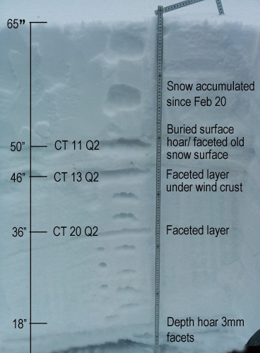
- <p>We've not received enough snow to be categorized as "heavy snowfall" but it is starting to stack up and drifts up to 2' deep were observed. Felt several collapses in the snow today, and observed minor cracking along the lee sides of ridge crests above tree line. Slabs were rather stiff and reluctant to move. Many were formed further down the slope than I was willing to go and test. A full depth pit revealed a few prominent weaknesses with moderate sheers in the C11-13 range, both on the faceted old snow surface from the February high presssure spell, and on deeper faceted layers. About 18" of 3mm depth hoar still exists at the bottom, with some bridging/strenghtening above. </p>
Snowpack
- Instability Comment
- <p>Wind slabs were stiff and stubborn today but still dangerous as you would likely trigger them once you were fully committed and further down the slope. Forecasted moderate to strong winds tonight will increase the danger as there is plenty of snow available for transport and more snow in the forecast. </p> <p>Persistent slabs are again becoming a concern as additional weight is added to the snowpack. This problem is most prevalent right around tree line on steep, rocky, northerly aspects. Many of the traditional starting zones higher up, were scoured out and or sastrugied during the February high pressure. </p>
5" of lighter density snow fell on top of the even lighter 5" we received on Thursday, for a slightly inverted new snow situation. We are now up to about 15" of new snow since last weekends storm and you can still feel the old snow surface underneath except in areas where blown in, or where the underlying surface was old re-crystallized snow.