
Quick report
- Aspect
- Northeast
- Red Flags
- Recent Avalanches, Collapsing, Rapid Warming, Poor Snowpack Structure
- Elevation
- 3170 m
- Slope Angle
- 29°
- Red Flags Comment
- <p>Temperatures were warm and the snow was hot increasing the likelihood for loose wet slides that have the potential to step down into old layers weak layers that exist in our poor snowpack structure on W-N-E aspects. Though it may look and feel like the middle of April, digging down will reveal the snowpack is still comprised of weak faceted snow and I am not at all seeking out steep terrain anywhere or the risk of it overhead. </p>
Photos as follows.
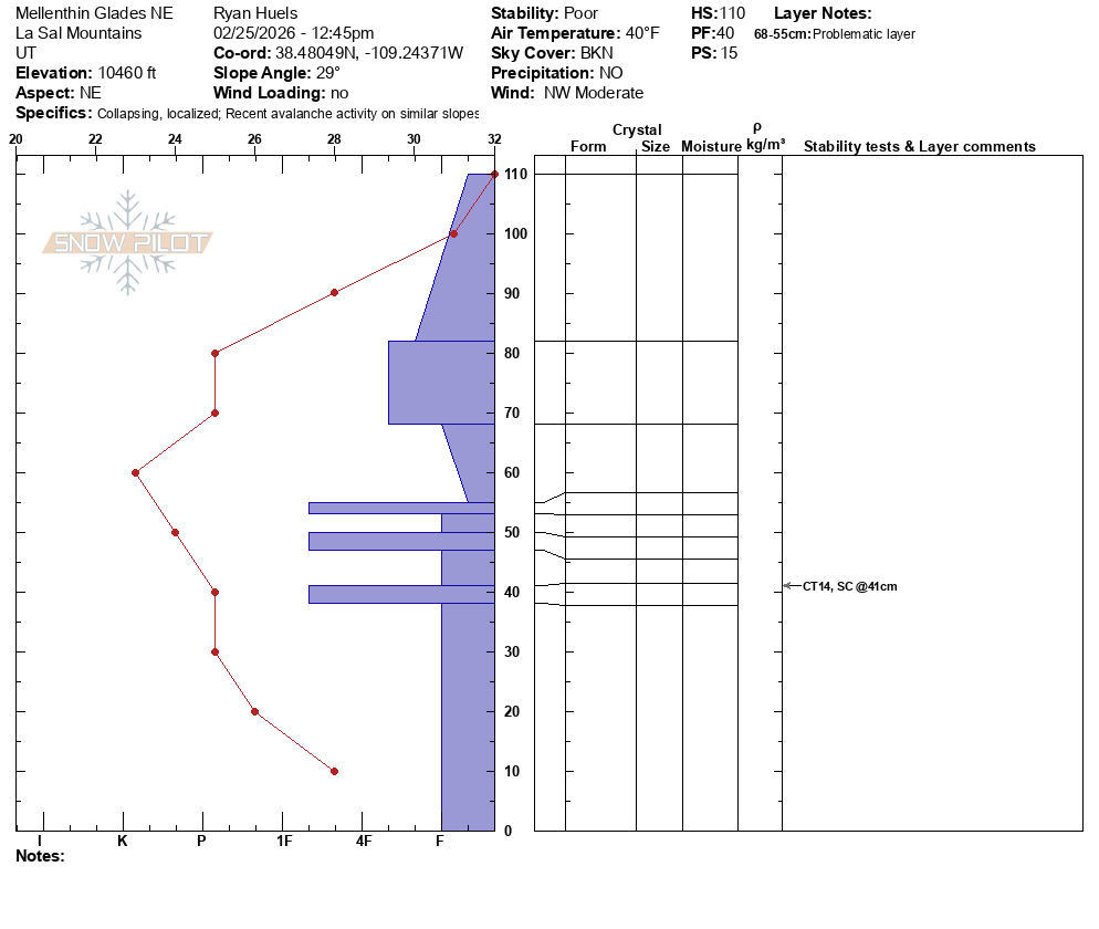
-Profile on NE aspect
-Another snow profile On W facing terrain around 10500’ showing CT 7 and 6 SC @ 35cm.
-A relatively recent looking avalanche that appears to have broke around 2’ deep on NW facing terrain due to warm temps and wet snow.
-Spring like looking snow texture, but not at all seeking out spring like terrain
Snowpack
- Instability Comment
- <p>Layercake of weak snow throughout the snowpack on NE and W facing terrain where I dug today. Instability results on both snow pits NE and W around 10500’ with compression tests showed possibility of deep and dangerous avalanches. </p> <p>No overnight freezing and warm temps increases the likelihood for wet slides that can gouge into the snow pack taking out old weak layers. I observed a small avalanche on steep NE facing terrain at 10400’ that appeared to be relatively recent as a result of recent warming. </p>
I did not make many turns as I spent the majority of my day skinning around and digging. But, what turns I did make on were straight up mush. If things do not re-freeze overnight the mash potatoes will come as leftovers tomorrow. Skiing is not great to say the least unless you enjoy that sort of thing. But, it is still beautiful out there and there is enough snow for off trail travel.