
Quick report
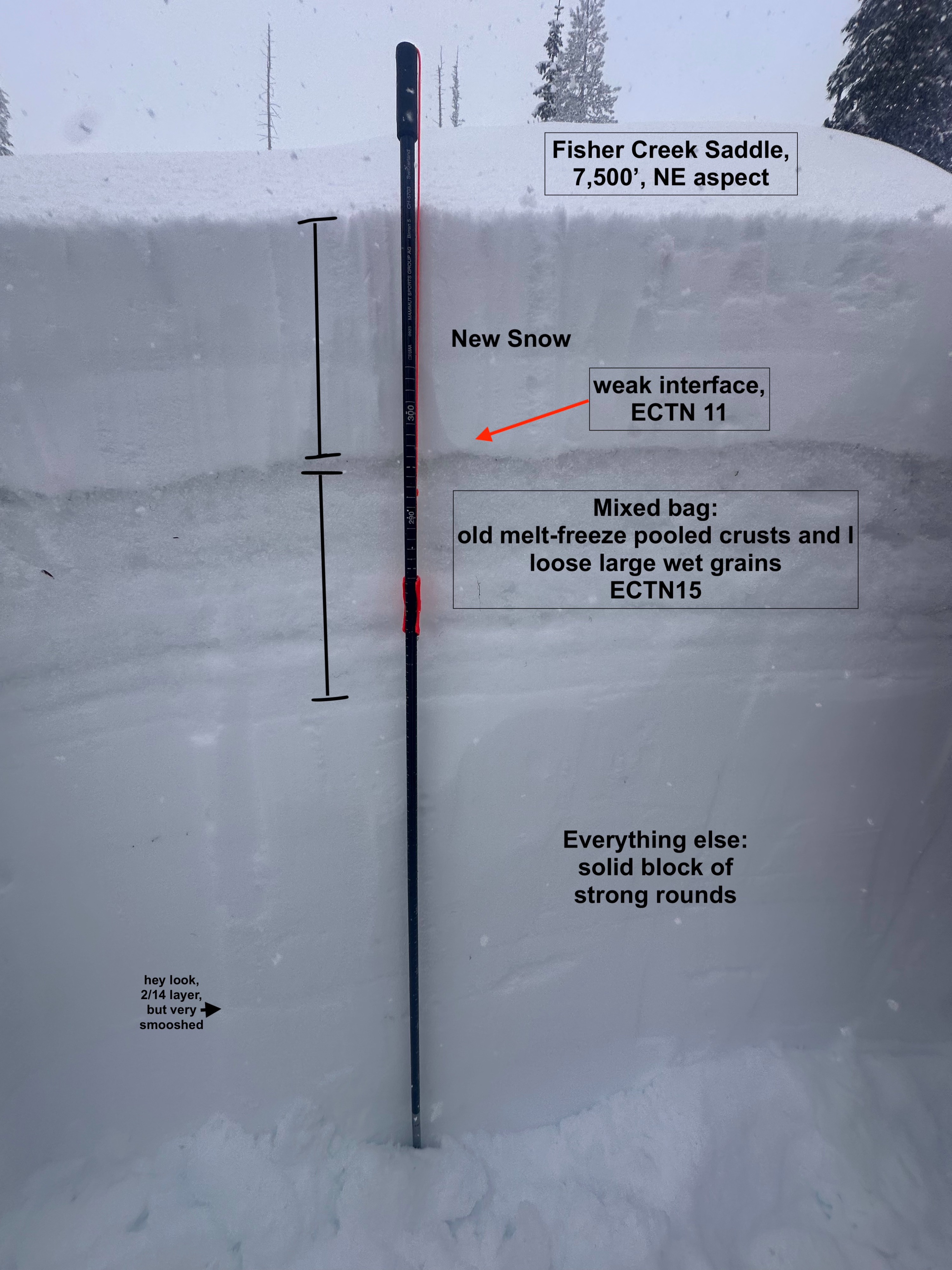
The old snow surface is a mixed bag of melt-freeze crusts and generally wet snow. A pit at 7,500' on a NE aspect revealed a total HS of over 300 cm, but we only dug around 140cm down, which was enough to locate 2/14 (for fun). Interestingly, only the top 2-2.5 feet of the snowpack here has been saturated, leaving everything beneath still predominantly moist, with no percolation columns. Snow pit tests highlighted weaker snow at the N/O interface (lighter-density grains that fell from 3/30-3/31 right at the interface, ECTN11) as well as smashed between two melt-freeze crusts (ECTN15), neither of which propagated or is composed of any type of persistent grain. However, with the vast grain size difference between this dry snowfall and the old snow surface remaining wet, I do think we finally have the recipe for wet slabs if things clear to full sun and hot temps Fri/Sat.
For the time being, with an additional 8-12 inches of snow (plus a healthy portion of zonal-flow W wind) favoring the northern portion of the Salmon River Range, we expect to see a wide range in avalanche activity. Many of these may be small and occur at low to middle elevations, running as wet-loose avalanches or point releases. Above 6,500, larger avalanche activity will most likely be in the form of wind slabs of newly-drifted snow. Either way, conditions moving into the weekend will become increasingly dangerous. March produced very little snowfall, but it’s time to turn the avalanche brain on once again. Cautious route-finding, traveling one at a time, and carrying the proper gear.
None observed, although our visibility was poor above 7500'. Noted no loose snow avalanche activity, but even avalanche activity initiated within dry snow will likely appear like a wet loose due to the moisture level of the new snow, in addition to the moist snow at the new/old snow interface.Weather
- Air Temp
- Not observed
- Cloud Cover
- overcast
- Wind Loading
- light
- Rain Elevation
- 6,500'
- Recent Snowfall
- 20
- Snow Avail For Transport
- small smounts
Snow above 6500', moderate to heavy wet snow at times with gusty SW winds. Cooling with snow starting to dry out more towards mid-day.
Snowpack
The overall height of the snow at 7,500 feet was about 3 meters (10 feet). Underneath the new snow, the upper snowpack is not frozen at the new old interface. Below 7,000', old snow remains saturated 1-1-1.5' down. Observed easy failures in the new snow just above the old snow interface on fluffier snow grains that came in while temperatures were cooler. There were also weak, wet, large grains sandwiched between two melt-freeze crusts formed by water pooling and refreezing throughout our heat wave. Both showed relative weakness but did not propagate in extended column tests.
Avalanche
Noted no loose snow avalanche activity, but even avalanche activity initiated within dry snow will likely appear like a wet loose due to the moisture level of the new snow, in addition to the moist snow at the new/old snow interface.