
Quick report
- Aspect
- South
- Red Flags
- Recent Avalanches, Poor Snowpack Structure
- Elevation
- 2957 m
- Slope Angle
- 30°
- Red Flags Comment
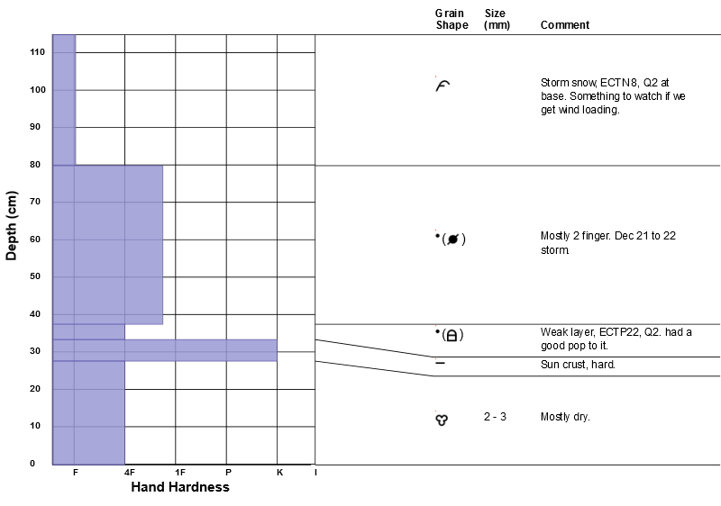
- <p>Looked at the Dutch Draw slide, definitely a red flag! Still not trusting the deep pack, this includes the lower ECTP as shown in my pit profile.</p>
Two days ago, I was thinking almost green light on south aspects, not so anymore with the last snowfall event (shear at base).
I still plan on avoiding steep aspects on the north half of the compass.
Bret did an awesome job on the Wilson Glade Avalanche Report, a great reminder about places we feel are sort of low angle.
Snowpack
- Instability Comment
- <p>On steep aspects. Decreasing danger if we do not get wind. Increasing with wind.</p> <p>Still lurking. Although more of a high consequence moderate probability scenario in my opinion.</p>
6" overnight. storm total is approx. 14 to 16". Generally easy to isolate columns in all areas traveled.
Of note: The base of the storm snow contains a shear zone. ECTP 1 to 4 (Q2) in NW facing Beartrap, this may be related to surface hoar.. A quick column to the ground in this area (9400', HS+130cm) indicates that the basel facets are healing. ECTN with a good pounding.
Snowpack still hard to isolate in shallow areas on the PC ridge. HS 60 to 70cm, failing in old facets.
One recent shallow slab (2-3" deep, 40' wide) in an area of NE facing Dutch Draw, likely happened during one of the high PI episodes yesterday or last night.
Based on my snow profile below, south aspects do not appear to be as stable as they were a couple of days ago.