
Quick report
- Cracking
- specific
Not as much new snow last night as forecasted. 2-4" in the morning. Heavy snowfall for most of the day S1-2 (1-2cm/hr). Strong SW shifting W wind and decreasing slightly throughout the day. Cross loading and wind affected snow began at around 8500' forming slabs less than 6" with cracking surfaces and easy hand shears. These areas were easy to identify with rippled/stiffened surfaces and pillows/drifts. Wind slab depth increased with elevation. Deepest slabs were 10-12" from 9,000-10,000', with sluggish character in steep terrain but easy hand shears. Active wind transport observed at and above 8500'. Lots of wind drifting snow occuring even in fairly sheltered terrain. Some slopes are scoured while others were quite deep.
This storm could bring a significant amount of snow throughout the weekend with 2-3' forecasted by Sunday. The good part is temperatures are forecasted to decrease. The unfortunate part is winds are forecasted to remain 20-30 mph Saturday. New snow has already set up into a slab on wind affected slopes and primed to avalanche with additional loading. Assessing the stability of the new snow and avoiding reactive wind slabs will be critical.
Found cracking on leeward and cross loaded slopes above 8500'.Snowpack
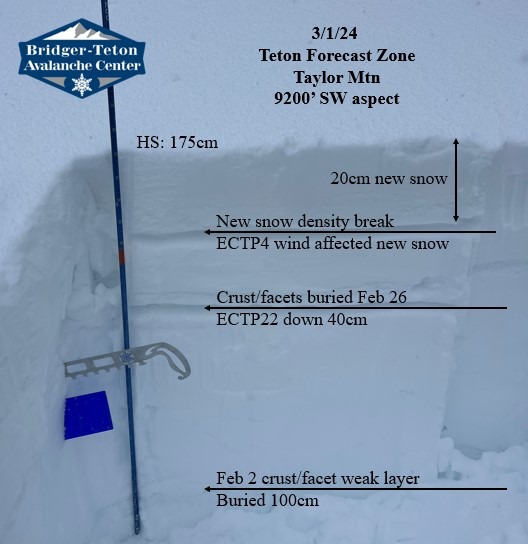
Probed the snow for awhile around 9200' across an array of aspects feeling for any weak snow buried 2/26. Weakest snow was found on a SW aspect so dug at that location. Found propagating results in pit. ECTP4 down 20cm on new snow (wind packed) interface. ECTP22 down 45cm below a melt freeze crust (2cm thick, 1F+) on facets (.5mm, dry). This interface was buried 2/26. Performed stability tests twice to verify results.