
Quick report
- Aspect
- Northeast
- Red Flags
- Recent Avalanches, Rapid Warming, Poor Snowpack Structure
- Elevation
- 2804 m
- Slope Angle
- 32°
- Red Flags Comment
- <p>Not sure how recent the avalanches are but 1 fairly recent release lookers right and above Blue Ice, this gully runs commonly. Ran onto the lookers left side of Diving Board (not uncommon). The east face of the twins also ran at some point, although there is newer snow over the debris. between this and the recent winds, not much snow up there. Slabs between Bonkers and the diving Board also ran down to bare rock. Less activity on solar aspects than I expected, this included looking down into LCC (one wet slab on a SE aspect, fairly minor).</p> <p>No real signs of instability while skiing today.</p>
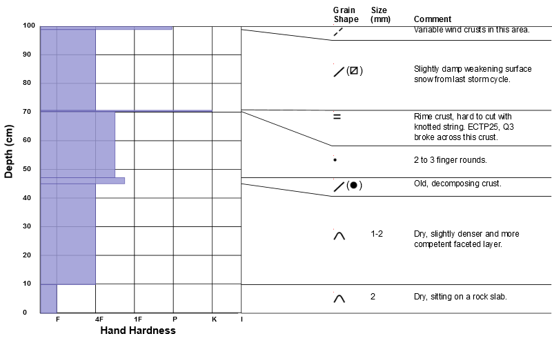
Snow profile in the vicinity of the Diving Board. No real surprises except that an ECTP broke across the rime crust (Q3). HS=100 cm in this area which I believe has not slid, it is sheltered from above by a rock/tree island.
I take 2 days of from skiing and the snow pack goes to all heck!
Moderate on sunny aspects and the lower elevations. Low or approaching low on shady north apscts.
Snowpack
- Instability Comment
- <p>This is my biggest concern right now. Moderate danger on sunny aspects. Waited until the afternoon shade to walk up the Diving Board.</p> <p>I think I am ready to say low danger for this. The next storm cycle may be a primarily new snow event (unless we get a huge storm!)</p>
Mixed bag!
A marginal surface refreeze below 8000' last night, damp below a light crust. Corn like skiing in places below 8000' on the exit at 4 pm.
Above 8000', very variable.
Still some areas of rotted to the ground facets near the base of Bonkers and around thin rocky areas above all the way to the BCC/LCC ridge. Followed a boot track (thanks!) to the O'Sullivan/Twins pass and wallowed a bit.
In open areas the snow surface varies from settled/recrystillzed snow to rock hard wind crusts. HS>140cm in places to 40cm in thin rocky areas. snow felt dry above 10,000'.