
Quick report
- Aspect
- North
- Elevation
- 2195 m
- Slope Angle
- 31°
First tour to Mt. Aire this season, and we dug 3 quick pits on NW through NE aspects to see if there were layers of concern here that we haven't seen in the Cottonowoods. Pits failed to reveal alarming instabilities, see below:
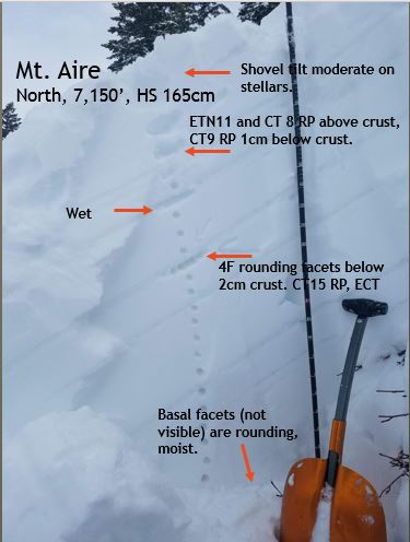
Low elevation: 7,150 North facing. New snow over a series of melt-freeze and rain crusts. No propagation in extended column tests, and the three CT results had resistant planar fracture character. Weakest snow was rounding facets below a 2cm crust, roughly 45cm down. Also saw unexciting results above and below a crust 20cm down. The crust 30cm down was actually wet, and better described as melt forms...a few cold clear nights could drive some faceting around this layer.
"Mid" elevation: 7,480' north east: Weakest snow was on rounding facets down 60cm below a 1cm crust, with ECTN23 and CT23 resistant planar (but closer to SP than elsewhere).
"High" elevation: 8,050' northwest: at this elevation there were no crusts within the top meter (and that's as far as we dug). ECTN within the new snow (see photo below), and 30cm down.
This was the only pocket of storm snow we got to move
Big, charismatic, juicy clouds felt like spring. Breaks in cover let through plenty of sun for dampening the snow surface. Also including the photo below to share a less-common view of Gobblers, Raymond and friends
Snowpack
- Instability Comment
- <p> The only storm snow instability we were able to kick loose was on a short 45° roll-over, where 5"x 30' failed on a weak interface within the new snow. Otherwise, storm snow well behaved. </p> <p>Little evidence of last night's possible wind-loading on our tour today. The exception was along the ridge lines, where we booted up through a small wind-pocket a group before us likely triggered. No blowing snow witnessed today.</p>
Only 2" of moist snow at 6,200' where we parked; the first piece of the storm came in as rain. The new snow was closer to 12" in the "upper reaches", at 8,500'. Lighter snow on top of denser snow made for great skiing up high. South east through southwest will have a stout crust on Sunday morning. At lower elevations, flat terrain and low-angle east and west aspect might also have a thinner crust.