
Quick report
- Aspect
- East
- Red Flags
- Heavy Snowfall, Wind Loading, Cracking, Collapsing, Poor Snowpack Structure
- Elevation
- 2896 m
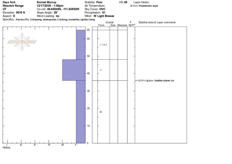
Headed up Days Fork to get a read on conditions as the storm comes in. Driving up the canyon this morning, the rain/snow line was around Stairs Gulch. Light to moderate snowfall with light wind started around 11am at 9000', but it was gusting on ridgelines with signs of obvious transport at higher elevations. The PWL from Mid-November isn't going anywhere anytime soon and appears to be most reactive in areas that have seen windloading. Dug a pit on an E aspect at 9500' and got a sudden planar fracture on an ECTP11 36cm from the ground. An ECT from an adjacent snow pit had a sudden collapse on isolation. In our opinion, the house of cards that currently exists in the Wasatch will start to topple this weekend as more snow and water is added to the snowpack.
Snowpack
- Instability Comment
- <p>Faceted snow from the mid-November storm cycle continues to be found on the Northern half of the compass and higher elevation slopes. Quick hand pits and hand shears throughout the day revealed that the PWL was fairly widespread in these areas. Some spots had stiffer snow around 1F hardness on top of the PWL. Other areas had F hardness of the new snow on top of the PWL. </p> <p>We were able to easily trigger a wind slab on a test slope on a NE aspect around 9700'. Currently, windslabs are in isolated areas and below ridgelines. In the next 24 hours, I suspect this will change and wind loaded slopes will be more widespread.</p>