
Quick report
- Red Flags
- Rapid Warming, Poor Snowpack Structure
- Red Flags Comment
- <p>As noted above warming was expected and the primary concern today. East facing slopes in this area still contain weak faceted layers that are only burried by 30 - 45cms in places.</p>
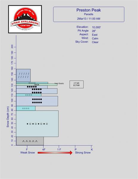
Our digging today showed some spatial variability. Our first pit was at 10000 feet and had a much thicker more consolidated snowpack than our second pit at 9700 feet. Snowdepth in the first location was 160cms vs about 120cms. It also had less in the way of facet-crust sandwiches.
In both the second and third pits we found we found roughly 10cms of 2-3mm facets about 45cms deep. Both the ECT and CT produced results in the low twenties with Q2 shears on or above this layer.
Snowpack
- Instability Comment
- <p>Wet avalanches were observed on more south facing slopes below rocky sections on Preston Peak. Rapid warming and damp snow indicate more wet slides are possible. Cooler temperatures tomorrow and next week will eventually produce a good re-freeze.</p> <p>In our 2nd and 3rd pit locations, we found roughly 10cms of 2-3mm facets about 45cms deep that sit on a very hard melt freeze crust that resembled water ice. In some places it was difficult to even saw through this crust. These consistently produced CT/ECT results in the low 20's with Q2 shears. Our first pit was in a thicker snow area and while persistent weak layers were present, everything seemed well attached and snowpit tests produced no results. It took a fair bit of effort to even separate the snow layers after our snow tests. </p>
Snow changed rapidly on east facing slopes today. By about 11 am, the upper elevation east facing snow was warming rapidly. Prior to this, the snow was largely supportable but after about 11:30am snow became considerably softer. About 300 feet lower it was possible to start medium sized pinwheels and the snow was considerably more damp.