
Quick report
- Aspect
- North
- Red Flags
- Heavy Snowfall, Wind Loading, Poor Snowpack Structure
- Elevation
- 2926 m
- Slope Angle
- 31°
- Red Flags Comment
- <p>The snowpack structure remains the primary concern on all aspects except true south. Increasing wind and snowfall are continuing to load weak, faceted grains. Looking ahead to tomorrow, I anticipate heightened sensitivity and a likely increase in widespread avalanche activity.</p>
Headed into Upper Big Cottonwood today to assess snow totals, sensitivity, and the interaction between the new snow and old snow interfaces.
On southerly aspects, the new snow primarily fell on bare ground or a melt-freeze crust at the surface. In shaded northerly terrain, it landed atop older storm layers and weak faceted grains. The snowpack in these areas includes multiple crusts from sun and warming periods, with signs of weakening at those interfaces.
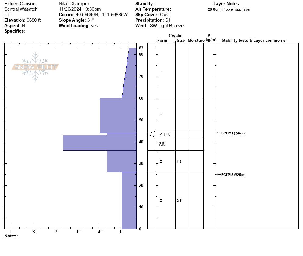
On a northerly aspect at 9,700', I observed propagation in an extended column test, both in small facets above a firm mid-pack crust and in the facets at the ground. Both layers remain a concern, I am unsure how widespread the mid-pack firm layer is but the facets on the ground can be found on all shaded aspects, and the likelihood of propagation will only continue to increase throughout the next 24 hours.
At upper elevations, winds appeared to be transporting new snow along ridgelines and sub-ridges, creating noticeable mid-slope texture. Shallow wind slabs are likely forming in these areas, which could sit atop weak, faceting snow, increasing the potential for cohesive slab development.
Snowpack
- Instability Comment
- <p> The new snow and increasing winds are gradually edging the buried facets closer to failure. While they haven’t shown signs of natural reactivity yet, I observed consistent propagation in my snowpit tests. With continued winds and additional snowfall, I’d expect to see:</p> <ul> <li>Small, sensitive loose dry avalanches in steep terrain.</li> <li>Small wind slabs along ridgetops.</li> </ul><p> </p> <p>However, my primary concern is when these new snow or wind-drifted avalanches begin stepping down to the buried facets, leading to deeper and more consequential failures. </p>
The recent snowfall came in as a bit of a density sandwich—starting cold and low-density, increasing in density through the peak of the day, and tapering off again by evening. Around 3 PM, a brief period of graupel was observed. Overall, the new snow in upper Big Cottonwood felt generally low-density. The riding was fun, especially on lower angle terrain or areas you didn't hit base.