
Quick report
- Aspect
- Northeast
- Red Flags
- Poor Snowpack Structure
- Elevation
- 3292 m
- Slope Angle
- 22°
- Red Flags Comment
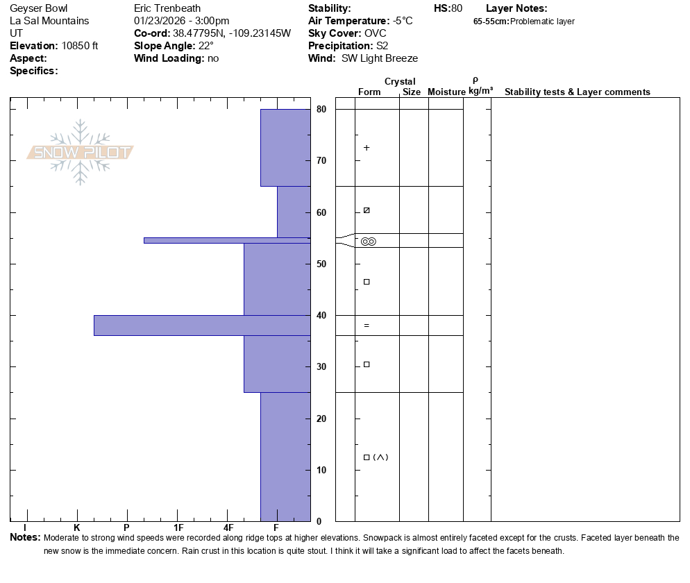
- <p>I went out today to have a look at the snowpack on a sheltered northeasterly aspect at the bottom end of our "near tree line" band. With the exception of a thin melt/freeze crust, and the Christmas Rain Crust (CRC), the entire snowpack was faceted through. In this location 6" of new snow sat directly on top of a faceted layer 4" thick. The thin melt/freeze crust was underneath. Poor snowpack structure has been well documented elsewhere, particularly on northerly aspects near and above tree line where old, hard slabs of wind drifted snow sit on top of the weak, underlying, faceted snowpack. </p>
Snowpack
- Instability Comment
- <p>New snow, driven by wind, will land on a variety of surfaces from slick and hard, to weak and faceted. In most cases the new snow will not bond well to any of them but the danger will depend on how much snow we get. We could see everything from shallow, loose snow natural avalanches on steep alpine slopes with underlying, slick hard surfaces, to human triggered soft slab avalanches where the new snow has been thickened or deposited by wind. Human triggered, loose snow avalanches could even gouge into weak, faceted snow on slopes similar to where I dug today. By and large though, we'll need about 8" or more of new snow for it to become a real problem. </p> <p>6" of recent snow sits on top of a faceted layer with a thin melt/freeze crust underneath. The rest of the snowpack is faceted with the exception of CRC. </p> <p>I don't think we are going to see enough snow to stimulate our ongoing persistent weak layer problem but if by some miracle we do pick up an inch of water weight, my alarm bells will start to go off. As it is, we have poor snowpack structure, and a low likelihood, high consequence situation regarding deep and dangerous avalanches failing on a PWL. </p>
3" of new, low density snow at Gold Basin (10,000') with up to 6" at 10,800' as of 3:00 PM. The new snow is falling on a variety of surfaces ranging from very weak facets in shady, sheltered areas to bulletproof hard slabs in the alpine, and everything else in between.