
Quick report
- Aspect
- Southeast
- Red Flags
- Wind Loading, Collapsing, Poor Snowpack Structure
- Elevation
- 3444 m
- Slope Angle
- 28°
- Red Flags Comment
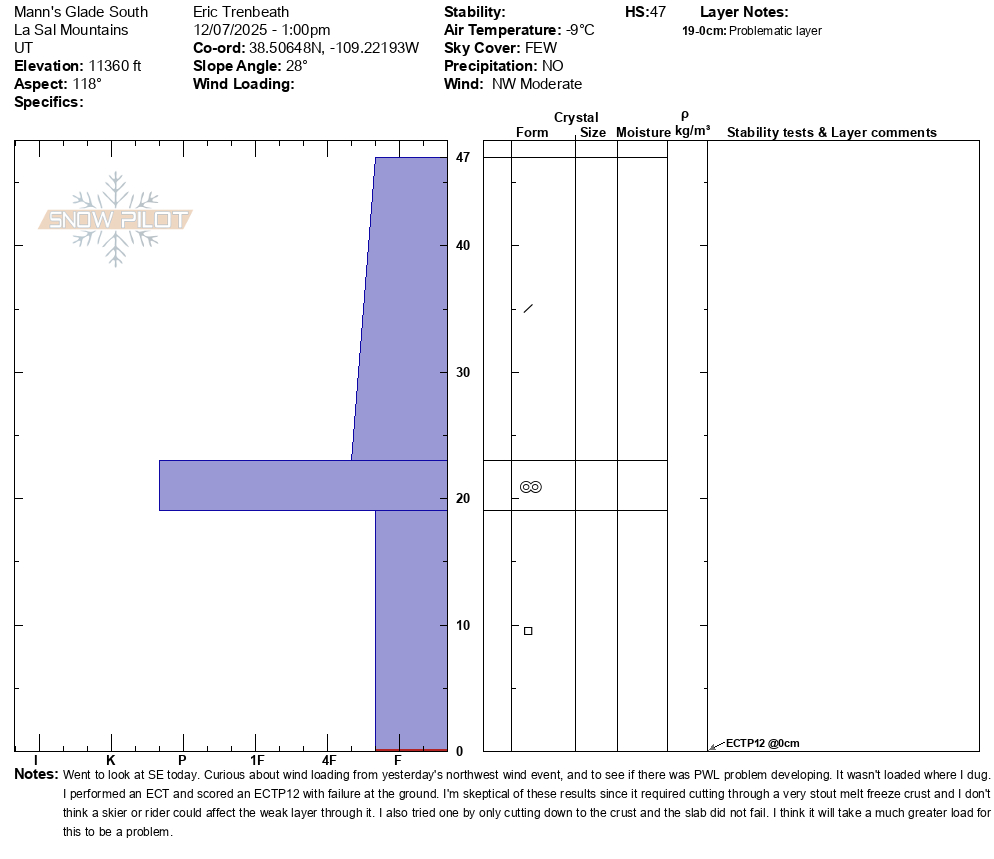
- <p>The red flags weren't super red. I observed wind loaded areas in the high country but didn't find widespread distribution in my travels. Drifted areas appeared to be most prevalent above treeline on SE-E aspects. I had a few isolated collapses where stiff slabs were sitting on top of weak, faceted snow. These encompassed very small areas. Snowpack structure is poor. The Nov 16-19 snowfall has pretty much completely faceted through on all aspects that I looked at today (S-SE-E). Snow from Nov 30 has settled into a cohesive slab of approximately 4f- density. </p>
East aspect, 11.400' 27 degrees
Snowpack
- Instability Comment
- <p>Although I observed drifted areas in the high country, I didn't find wind slabs to be sensitive today near tree line or below today. I expect recently formed slabs will stabilize fairly quickly and will soon become part of the persistent weak layer problem. </p> <p>Recent drifting on a SE aspect on peak in the background. </p> <p>Our overall poor snowpack structure is indicative of a nascent persistent weak layer problem. Weak, faceted snow exists on all aspects and an overriding soft slab exists with varying degrees of reactivity. I scored an ECTP12 with failure at the ground on a SE aspect but I had to cut through a very stout melt-freeze crust which makes the result suspect. I scored and ECTP12 on an east aspect with a much thinner crust, and failure at the top of the faceted layer. This seems more indicative of the sensitivity. The overall shallow nature of the snowpack and lack of connectivity calls to mind "small avalanches are possible on isolated terrain features" nevertheless, it's hard to ignore the structure and propagating test results. If we were to receive another load, we would certainly have problems, particularly on slopes facing the north half of the compass, but for now they seem spotty. And with the coming weather forecast, it appears we will trend toward more stable conditions and a weakening snowpack. </p> <p>Snowpack on a S aspect at 11,000'. Shallow with a 4f- slab on top of a stout melt-freeze crust. Facets underneath. </p> <p>Similar snowpack on SE at 11,300' but with a slightly thinner crust. </p> <p>Slightly deeper snowpack on an E aspect at 11,400' with a thinner crust/crust-facet sandwich above the basal facets. </p>
The snow surface definitely took a hit from the northwest wind event yesterday. Open areas were wind crusted or sastrugied, while the highest peaks were scoured down to the rocks in many areas. Below tree line, soft snow could still be found in sheltered areas but overall coverage remains thin, between 16-24 inches with numbers on the lower end on southerly aspects.
Wind affected snow in an open area well below tree line at around 10,200'.
Wind affected snow above tree line along a ridge crest at 11,600' with scouring on a westerly aspect.
Scoured north and northwest facing slopes above tree line.
Soft snow in sheltered terrain.