
Quick report
- Aspect
- North
- Red Flags
- Wind Loading, Poor Snowpack Structure
- Elevation
- 2987 m
- Slope Angle
- 24°
- Red Flags Comment
- <p>Wind wind wind wind, I sound like a broken record lately, but Uncle Gusty has not been kind to us. Continued moderate and strong winds blowing from the SW. While on the Pre Laurel ridgeline today I actually had to sit on the ground and hunker down so I wouldn't get blown over. You can expect wind loading in the obvious places. But with this much wind most aspects above tree line can be loaded, with fresh drifts further down slope than we typically get. Watch subtle terrain features for cross loading. </p>
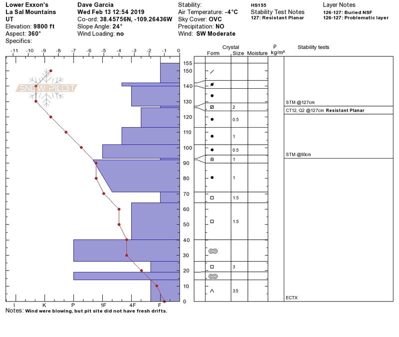
With all the snow falling lately, we've developed some other layers of interest towards the upper part of our snow pack. We have a layer of buried near surface facets beneath the snow that fell on Sunday 2/3. Last week there was some discussion about whether or not this might be some buried surface hoar. Today I was able to positively ID this layer as buried facets. I'll post some photos below of it's location in the snow pack. I found this layer at 127cm. The new snow pulled off as a block on this interface with moderate shovel shears. This layer also failed a compression test CT12 Q2 RP. This layer did not react to the ECT (ECTX). This is not a huge concern to me right now, but if we add a bigger slab on top of this weak layer, we could potentially see some failures here. The next couple days should give this layer a good thumping and we'll see how it reacts.
One other thing I'd like to mention about today's pit. After both the compression test and ECT, I was able to pull out the entire column as one cohesive unit all the way to the ground.
In the first photo, the crystal card is sticking into the layer of buried near surface facets. You can see the interface across the pit wall as a thin dark line. The second photo shows where the block pulled off with a shovel shear on top of the buried NSF. Third photo is the entire column of snow as a cohesive unit.
A very scoured looking SW face above treeline and a short video clip of the winds on Pre Laurel Ridge.
Look for rising avalanche danger over the next few days with more snow and wind in the forecast.
Snowpack
- Instability Comment
- <p>Increasing danger as long as the winds keep howling.</p> <p>Today was a good day to get down off the ridge lines and hang out in a snow pit. I dug on a north facing aspect in hopes of adding to the conversation of whether or not the December facets are gaining strength. Todays pit was just between low and mid elevations around 9,800 ft. on a north facing slope with a steepness of 24 degrees. The December facets were not reactive to a compression test and an extended column test (ECTX). The layer in question is between 71-64 cm in the snow pit pictured below. From 80 to 60 cm there is a change in temperature of 1.5 degrees C. </p>
A mixed bag of snow surface conditions. The wind has really had it's way with the snow surface in any open areas. The north woods has soft snow, but this latest round of seven inches was not enough to fill in all the old tracks in there. Tonight's snow should take care of that.