
Quick report
- Aspect
- East
- Red Flags
- Wind Loading
- Elevation
- 2896 m
- Slope Angle
- 25°
- Red Flags Comment
- <p>Snow transport was visible at upper elevation ridgelines.</p>
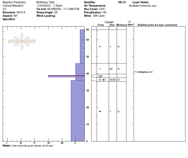
We went up to Dog Lake (Brighton) this afternoon to check how the snow from 11/02 was bonding with the old snow. Skies became overcast quickly around noon, which was accompanied by increased winds. Mid-elevation winds seemed to be predominantly SW while upper-elevation ridgelines had visible snow transport in all directions. We dug a snowpit on an E facing slope at 9500' and found the height of snow to be 66cm. The new snow from 11/02 had consolidated to 27cm of light powder with a slight increase in density 20cm down. This new snow was sitting atop a breakable 1F melt-freeze crust. We performed a shovel shear test that produced a moderate result just above this layer (STM @ 41cm, Q1).
Below the MF crust, we found 2cm of small faceting rounds (.1-.5mm), which were sitting atop 35cm of F+ 1mm rounds to the ground. There wasn't much to talk about regarding the snowpack other than how thin it still is. I am more interested in the strong winds and dense snow forecasted to hit the area in the upcoming days.