
Quick report
- Slope Angle
- 37°
Avalanche
- Slab Width
- 76 m
- Weak Layer
- Facets
- Trigger Type
- Skier
- Vertical Fall
- 244 m
- Avalanche Type
- Hard Slab
- Slab Thickness
- 91 cm
- Trigger Detail
- Remotely Triggered
- Start Zone Aspect
- Northeast
- Avalanche Problem
- Persistent Weak Layer
- Start Zone Elevation
- 2774 m
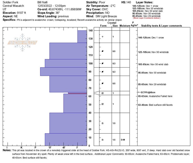
Our party triggered this HS-ASr-R4, D2-O at the top of Soldier Fork just northeast of Soldier Peak while ascending along the ridgeline approx 6' away from the slope. It picked up speed quickly and propagated 250' taking out the whole slope to the old faceted snow surface from the Nov dry spell. Loud powerful collapse at the ridge and then it traveled fast into dense aspens then conifers and then out of sight. We estimate it ran all the way to the bottom of the slope 800' below. Not a survivable ride if caught in this one. First three pics courtesy of Mark White.
Snow along the Millcreek ridgeline is noticeably weaker than in the central cottonwoods. This mid elevation NE facing slope was nearly all faceted prior to the November 29-30 wind event. The slide took out the weakest facets closest to the old surface but didn't clean out the remaining 60cm. No Bueno. We tickled a few other slopes but saw nothing else this sensitive and weren't willing to get close enough without exposure.
This poor structure exists on many other slopes throuhout the range but it seems this mid-elevation band might have a slightly less dense and weaker slab. The higher up I've travelled the harder the slab worrying for future loading events. Steep shady slopes must be considered off limits for a bit.
SW aspects iu Butler Basin have been stripped bare from the Nov 30 wind leaving very shallow snow on brush. Where did all the snow go? North thru East-facing slopes on the other side. The higher up you go the more dense the hardslab resting on the weak old surface and this will worry us with each new succesive load for some time.