
Quick report
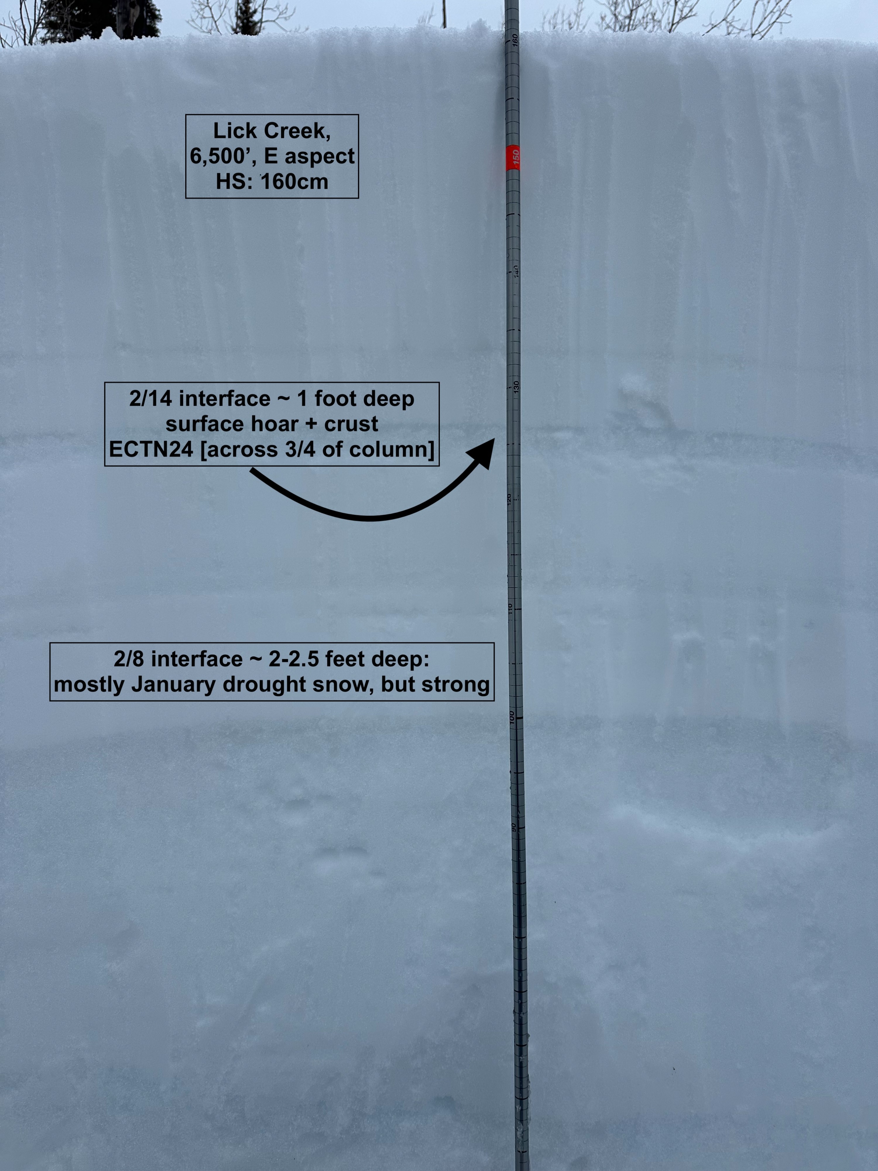
I poked around the middle elevations of both Black Lee and Beaverdam to check out the 2/14 and 2/8 layers. Both have had some time to "rest" without much additional change since February 17th, other than continued winds and above-average warm temperatures. 2/14 appears to be more reactive among the recent string of human-triggered avalanches across both zones. Both may be more problematic at middle and upper elevations in the West Mountain Zone, where depths at which they are buried remain shallower. A pit on an east aspect at 6,500 feet revealed a 165cm snowpack (6 feet deep) with both 2/14 and 2/8 clearly present. 2/14 resulted in a high-strength ETCN score that nearly propagated (ECTN24), and was located around 35 cm below the snow surface (~1 foot deep). This layer was composed of a degrading crust and large-grain surface hoar. 2/8 was located around 60 cm below the snow surface (~2 feet deep) and showed high strength, with firm/moist large-grain rounding facets and well bonded to the strong slab above it.
My takeaway from this glimpse into the snowpack, in conjunction with recent observations and the incoming weather pattern: This will be a weird, warm storm. Whatever strength these weak layers have gained over the past week will be tested during this event. Lots of moisture is incoming (1-2" of water), with plenty of uncertainty as to where the rain/snow line will start, and where it will rise to. This storm is set to unfurl throughout the day tomorrow, so expect rapidly changing conditions. Even without the weak snow layers in the top portion of the snowpack, the overall structure itself speaks to instability. Fine-grain, decomposing snow from last week is sitting atop 2/14, which, even if the PWL present there has gained strength, is very likely just a much larger grain of crystal, some of which are also sitting on a crust. This very simple setup of smaller-grained snow particles on larger-grain particles can be a perfect recipe for wet slab avalanches, particularly if rain lines rise between 6,500 and 7,000 feet. Regardless, plenty of snow and wind will fall throughout the next 48-72 hours, and it is likely that many small to large avalanches will fail throughout this storm period.
Weather
- Cloud Cover
- broken
- Wind Loading
- previous
- Snow Avail For Transport
- none
Light graupel/drizzle starting upon egress around 1545.
Snowpack
I toured up to around 6,800 feet but lacked the inspiration to go higher due to breakable crust downhill conditions. The top 6-8 inches of the snowpack below 6,000 feet was wet and unconsolidated, while above 6,000 feet (and subject to cooling from the wind), a surface crust was present atop moist, decomposing snow from last week's storm. Both 2/14 and 2/8 layers could be felt via probing.