
Quick report
- Aspect
- Northwest
- Red Flags
- Recent Avalanches, Wind Loading, Poor Snowpack Structure
- Elevation
- 2926 m
- Slope Angle
- 23°
- Red Flags Comment
- <p>One persistent slab avalanche triggered yesterday on NE aspect. Less wind loading than I had expected, since winds were quieting down by the peak snowfall.</p>
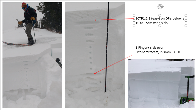
As we neared Kikkert's avalanche from 1/20, we had minor cracking in a small wind slab facing NNW. Dug down, primarily interested in how wind slab bonded to surface (full propagation with light taps). Took a peak at the full profile: slab thicker and harder than in many locations, still sitting above 2-3mm fist-hard facets that look ominous but were unreactive in our ECT.
Below is a photo from Kikker'st slide: wanted to show how nasty it would be trying to dig someone out from debris piled against a tree.
The Pointy Peak avalanche looked to be 100' wide, on a 38 degree slope facing NE. It took a heavy handed 31st tap to make the extended column fail, but it did propagate a fracture at the same facet layer on which the avalanche failed.
Greg had seen an avalanche at Pointy peak on 12/28 and we wondered if yesterday's slide was a repeater. Nope.... the previously noted slide was to the skier's right of this one. Similar to other avalanches we've seen, this slide left behind facets for the future.
Snowpack
- Instability Comment
- <p>Moderate to strong winds from a variety of directions. Snow devils, visible transport. Nonetheless, much of the surface remained soft powder and the wind slabs were not very active on our tour.</p> <p>Not sure that 0.3 to 0.4 inches of water will be enough load to bring about more avalanches on the weak facet layer, but in areas where wind-loading augments snowfall there could be increased hazard.</p>
Should be excellent sliding tomorrow! Light snow started at 2 pm, was heaviest around 4, and was light again by our 6pm exit. Wind speeds had lessened by mid-afternoon. Crust on solar aspects could still be felt under the new snow, although some steeper south slopes were frighteningly bare so soon after the storm last weekend. With sun angles climbing and snow depths that allow light penetration to the ground, its hard to imagine how we'll build a snowpack on those aspects.
Wind slabs and drifts present, but less sensitive (less cracking, collapsing or sliding) than expected. Weak faceted snow remains at the base of the pack, but yesterday's Pointy Peak avalanche was really our only evidence that it can be activated.