
Quick report
- Collapsing
- isolated
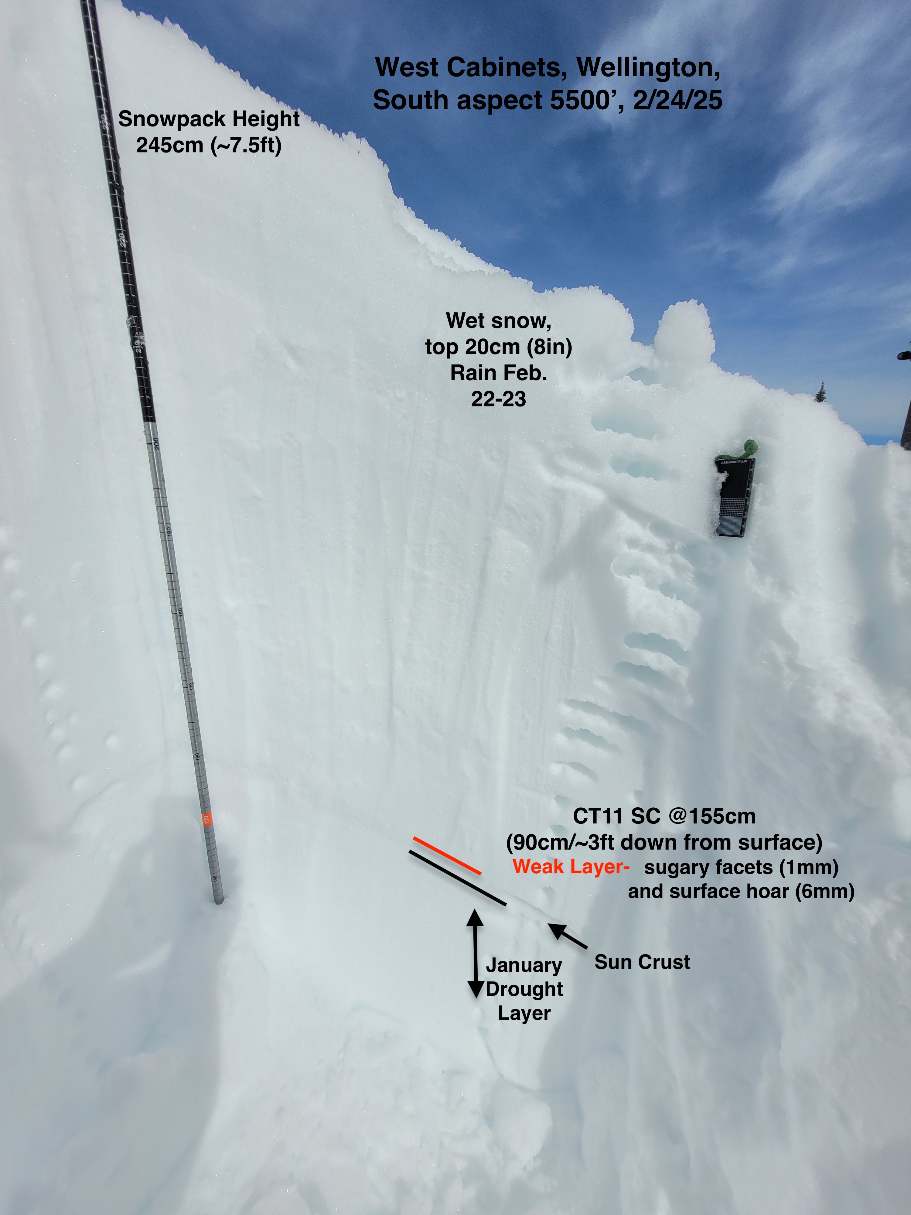
Triggered small road cut slide, 10 feet wide and 30cm (1ft) deep on a sun crust, on south aspect. It slid 6 inchs down slope before slope friction and road bench concavity stopped it. Nearby on similar slope Observed a loud collapse on 15 degree slope on South aspect 5500' in spare treed opening, The full profile pit, snowpilot, is from near here.
Weather
- Cloud Cover
- broken
- Snow Avail For Transport
- none
Partly sunny and clear skies with calm winds transitioned in the afternoon to fully overcast with light southerly ridgetop winds. Temperature were warm enough on sunny south facing slopes to cause surface melting mid day. By 2pm with cloudy skies the southerly aspects were beginning to re-freeze.
Snowpack
Numerous natural avalanches occurred within the last 2 days. A lot of rain was introduced to the snowpack. The lower portions of the Wellington drainage had numerous small to large natural wet loose slides that occurred in steep terrain over the weekend. Below about 4500’, the snow surface was very wet, down about 40cm. Between 5000 - 6000’ the top 20cm (~8in) was wet. Snow surfaces varied at these elevations between nearly supportable to breakable to thin and barely existent crust. In the area we traveled today, nearly widespread gaupel (ave. 4mm) was on the snow surface sitting upon the varied surface crust. Between 5000 to 6000, had a variable thickness and hardness surface crust.
We triggered a snowpack collapse in two places along our travels. One was a road cut that cracked 10ft wide by 30cm (1ft)) deep (on a hard sun crust) and slid downhill about 0.5ft before slope concavity and friction stopped it. We observed a loud and noticeable collapse in a sparse treed mellow open slope. We dug a snowpit nearby at 5500’ on a S-SE aspect. A column test produced a sudden collapse result with moderate force down 3ft from the snow surface (CT11 SC down 90cm on 1mm sugary faceted grains and 6mm surface hoar) This surface hoar sits on top of a sun crust which sits on top of the January Drought Layer (JDL). At this pit location, this one point in space- (differing from other aspects and elevations), the JDL was 1F hard and contained more rounds than angular snow grains (both forms size 0.5 - 1.0mm).
A natural avalanche recently occurred on the south-south/east aspect of Round Top proper, (SS-N-R4-D2). The average slope angle of this slope is estimated to be 30 degrees.
We crested the 6000’ ridgeline to find a large natural avalanche had slid on the north aspect of Round Top mountain. The crown line crossed the entire slope and wrapped around a bowl feature. A few small/medium sized broken trees were seen in the bottom debris piles. We saw in a couple spots of evidence, and were able to confirm by digging at the crown line, the slide initiated within top 1ft upper storm snow layers and stepped down to the JDL 80cm down from the surface in this location. At this Northerly aspect location near ridge top the JDL was small (1.0mm) surgery faceted grains of the 30cm thick snowpack layer weak layer. Did not observe buried surface hoar at this interface, but its potential presence at this location cannot be compleaty ruled out.
Avalanche
- Size
- D2
- Count
- 3
- Aspect
- W
- Trigger
- N
- Elevation
- 5000 ft
Numerous small to large wet loose, Large New snow and persistant slab avalanches observed, see attached details.