
Quick report
Light dry snow in top 1 ft of snowpack at middle and upper elevations. Good riding as far as current snow quality conditions. Overall snowpack is consolidating in upper elevations, filling in terrain vegetation and creating continuity across slopes. We found isolated cracking in wind drifts along ridgetop and intermittent southerly gusts were strong enough for moderate snow transport.
Isolated cracking in recently formed wind drifts along ridgetop.Weather
- Cloud Cover
- overcast
- Wind Loading
- light
- Recent Snowfall
- 25 -35 cm since 11/22
- Snow Avail For Transport
- moderate amounts
Stronger winds and less precip than forecasted during today. Variable winds, calm to moderate South wind gusts. Moderate snow transport occurring on exposed and ridgetop slopes. Light to no snow precipitation during the day.
Snowpack
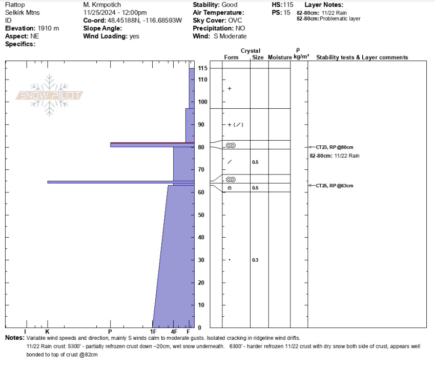
Snow depths steadily increase above 4000’. From 4000’ holding 30 - 50 cm (1 - 1.5 ft) of snow to 6300’ with 100-130 cm (3 - 4 ft) of snow currently. At 5300’ the 11/22 rain crust down 25 cm is partially frozen pencil hard crust, light dry snow above and wet snow underneath crust. At 6300’ 11/22 crust is down 35 cm as a 2 cm thick pencil/knife hard crust, with dry snow throughout the snowpack. The recent snow over the weekend appears to be bonding well to the top of the 11/22 crust. The November 12 rain crust down 50 cm is knife hard and 1 cm thick where we dug on a 6300’ N/NE aspect. Small sugary faceted snow exists below 11/12 crust, yet test results here remain stubborn. Below 11/12 crust to ground is 4F to 1F hard, small rounded grains forming a strong bonded snowpack base. Overall current test results are producing resistant planar results.