
Quick report
- Aspect
- East
- Red Flags
- Poor Snowpack Structure
- Elevation
- 3170 m
- Slope Angle
- 25°
- Red Flags Comment
- <p>Minor collapsing noted as well. </p>
It's a matter of knowledge, awareness of one's own level of acceptable risk, and decision making.
Knowledge : The areas that did not have old weak snow from Oct 23/24 are mostly stable. These are southeast through south through west facing terrain. Also shady terrain below perhaps 8500' (conservative estimate).
Level of Acceptable Risk: This is different with everyone and based upon many factors - be comfortable with yours and find other partners who have a similar level. Make sure your risk is for the right reasons...
Decision Making: The blue arrows indicate where folks have been riding lately - east-southeast and south - the red arrow - facing north - is where a 2.5' deep and 60' deep slab was intentionally triggered.
This also goes for north-facing terrain. North-facing terrain chosen today was low angle.
Tensile fractures noted from the last couple of days...
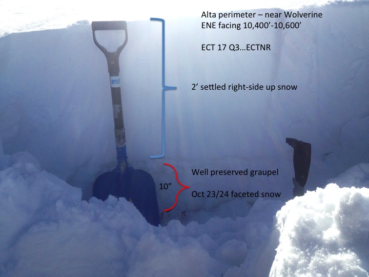
The basal weaknesses from the old October snow.
Snowpack
- Instability Comment
- <p>A couple of things. The basal facets are starting to adjust to the new load...and the slab is starting to settle into a denser, more cohesive slab. Classic good news/bad news situation. I suspect that triggering will become more difficult. That's the good news. The bad news is that this will likely allow folks to hit a couple lines and get away with it...until the 3rd slope. Or...4 folks may hit a line and it'll be the 5th person who's not so lucky... </p>
Feathers of surface hoar overlie near-surface facets....