
Quick report
- Aspect
- East
- Red Flags
- Recent Avalanches, Heavy Snowfall
- Elevation
- 2957 m
- Slope Angle
- 30°
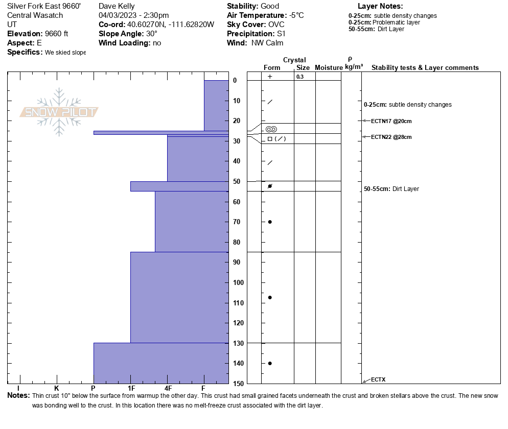
Height of snow was 407cm. There was a thin crust 10" below the surface from warmup the other day. This crust had small grained facets underneath the crust and broken stellars above the crust. The new snow was bonding well to the crust. In this location there was no melt-freeze crust associated with the dirt layer. Extended column tests showed no propagation.
I would put the danger at higher elevation steep terrain at Considerable for triggering a new snow avalanche and I saw signs of long running new snow avalanches (JAWS) that I would not have wanted to be involved with. Lower angle terrain (right at 30 degrees and less) was more Moderate avalanche danger. I traveled as though it was Considerable danger today.
Photo 1-Snowpit
Photo 2-Dry loose avalanche in Silver Fork
Snowpack
- Instability Comment
- <p>Photo below of new snow cracking out on a steep test slope. It broke on a density change within the new snow. The new snow had bonded well to the old crust and these density changes should settle out over time. I noted some natural dry loose activity in steeper sections of the Silver Fork Headwall and Jaws into Day's Fork ran naturally during the storm (probably during a period of increased snowfall rates). These new snow slides were big enough that they created small powder clouds as they moved down-slope. </p> <p> </p> <p> </p> <p>Photo of small dry <a href="https://utahavalanchecenter.org/avalanche/77843">new snow avalanche </a>running on a density change. On south facing slopes around 530PM they were starting on a density change and then stepping down and running on another new snow density change just above the crust. At the time of my exit they were still confined to gully features and breaking out at my skis on <a href="https://avalanche.org/avalanche-encyclopedia/#test-slope">steeper test slopes</a>. I would not have wanted one of these slides to break above me and with any hint of increased winds I expect them to pack a bigger punch. </p> <p>As winds pick up there is a lot of low density snow for transport. This hazard will increase and I would expect that we start to see more natural activity that is initiated within the wind-drifted snow. These wind-drifted snow avalanches have the potential to run long and far during the storm. </p>
New snow was medium density to start and moving to low density as the tour went on. Periods of very light snow up to an inch an hour. Snow was primarily falling straight down with little to no wind affect.