
Quick report
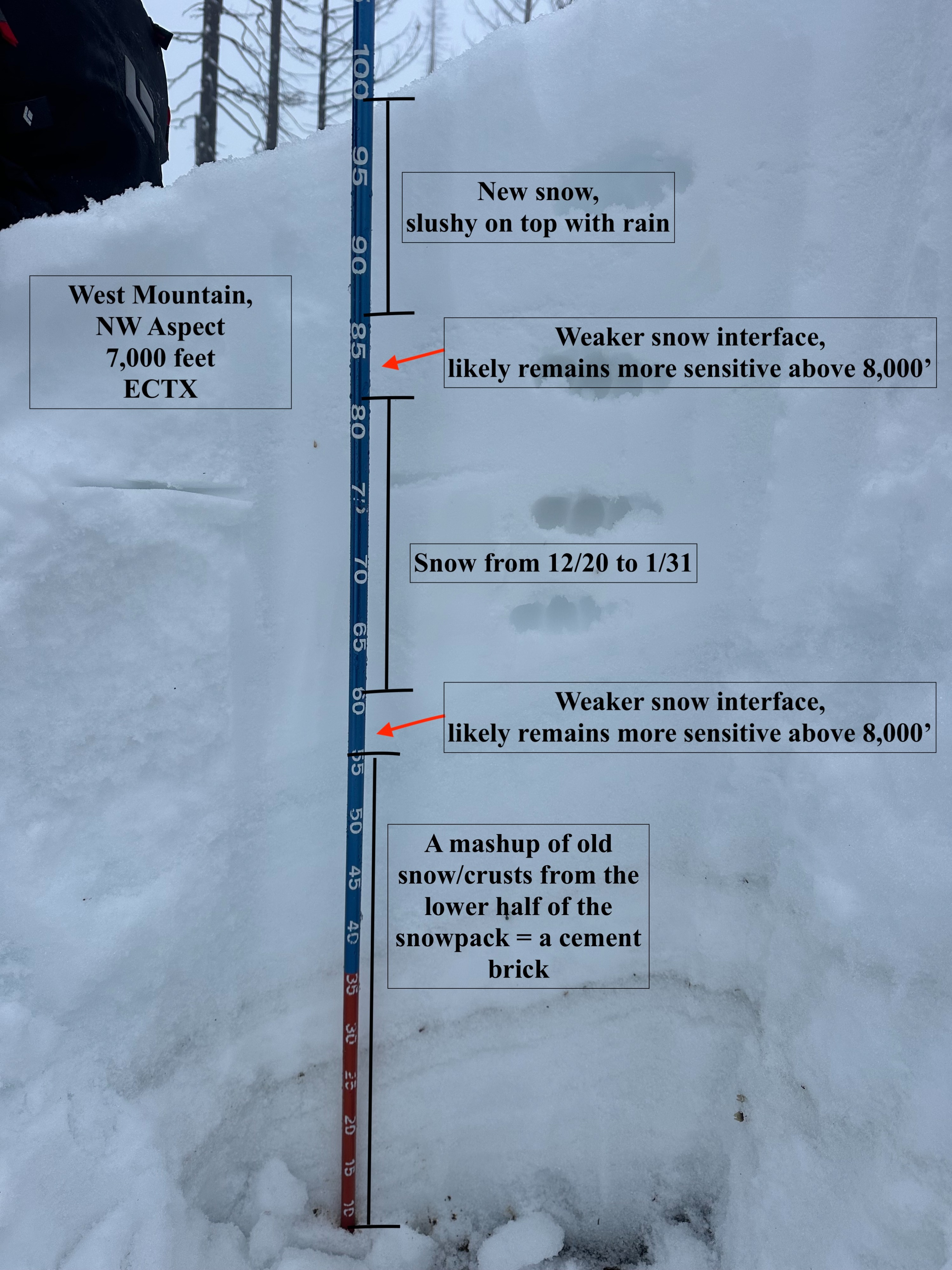
As noted above, access via Anderson remains fairly dry for the first two miles, with even less snowfall near the end of the day due to rain melting snow held on the road. We rode south from Four Corners along the ridge, but with poor upper-elevation visibility. We could not get above the freezing rain line and opted to check out a slope around 7,000 feet on a NW aspect. Due to frequent rain-on-snow, the snowpack above that elevation at 7,000 feet was also 100 cm (3 feet). The bottom 60 cm of the snowpack is composed of hard, older snow and crusts. Any faceted, weak snow near the base of the snowpack has been fully saturated, is rounding, and is currently strong. The top portion of the snowpack, around 40-45 cm (1.3 feet), is new snow from 12/24 onward. Several layers of weak snow exist in this chunk of the snowpack, and can be found in a bit based on a subtle hand-hardness difference and visual ID. They are composed of a mix of graupel and near-surface, faceted snow. Two layers were around 5 cm thick before burial, but due to the nature of this dense, heavier snowfall, they have compressed to around 1-2cm in thickness and were not reactive where we traveled. They are located around 8 inches deep, and the primary one, around a foot and a half deep, atop the 12/24 rain crust. Our test pit yielded no results (ECTX), and probing at various spots along the route revealed little to no weak pockets of snow.
With all this said, the nature of weak snow in this range will be spotty and found in certain terrain features that are few and far between, so evidence is rare and difficult to find. Areas seeing less warmth and rain, and more dry snowfall, should remain suspect (likely ranging 8,000 to 9,000 feet and above). If traveling to very steep terrain at upper elevations, avoid sensitive drifts of new snow (particularly as winds increase tomorrow) and ridgelines with growing cornices.
Weather
- Air Temp
- 34
- Cloud Cover
- obscured
- Wind Loading
- none
- Rain Elevation
- 7,000, likely above this as well
- Recent Snowfall
- 15-20 (6-8 inches)
- Snow Avail For Transport
- none
Light rain with intermittent clearing throughout the afternoon
Snowpack
New snow remains upside-down, with lower-density snow sitting beneath higher-density snow that is also being rained on. Though road conditions remain fairly dry for the first 2-3 miles of Anderson Creek, the average snowpack depth rapidly increases once you hit 6,400 feet to around 80-100cm (2.5 to 3 feet).