
Quick report
- Aspect
- Northeast
- Red Flags
- Poor Snowpack Structure
- Elevation
- 3170 m
- Slope Angle
- 26°
- Red Flags Comment
- <p>Not many red flags today. No collapsing or cracking, no wind loading, and new snow was very light density. Unless you dug down to the ground, one could be fooled into thinking we didn't have an avalanche problem......</p>
Video discussion of snowpack structure in upper Days Fork.
Ski conditions were good! New snow was very light density and we were finding the rime crust from Friday morning to be quite thin (at most 1 mm) so you almost didn't even notice it. Our first run was in Upper Days where there is a bit of a SE aspect and there was much more of a thicker temperature crust (5-10 mm). I was not out on Saturday, but am guessing this may have formed from sun and warm temps. Regardless, the snow that fell this morning was bonding very poorly to the crusts at the old snow surface.
Calling the hazard Moderate, but it is clearly "high consequence" Moderate. This may be a lot of arm waving that will make very little difference if precip numbers come in as forecasted.
Snowpack
- Instability Comment
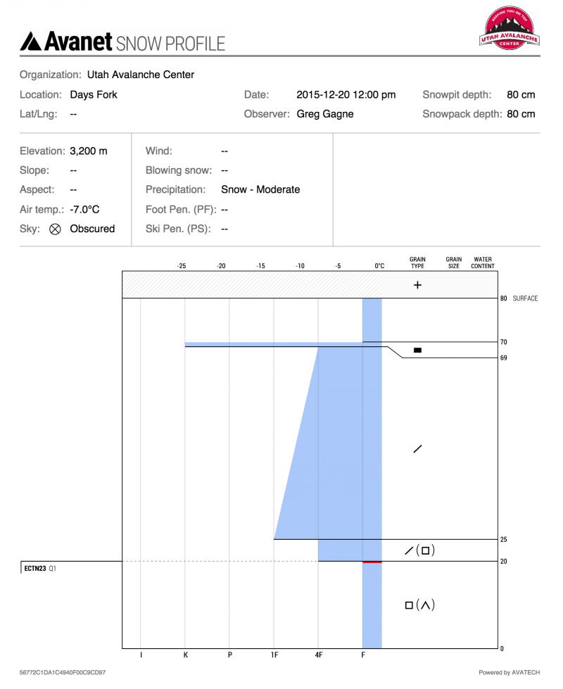
- <p>but unfortunately we do. Today was interested in seeing how the storm snow slab from storms this past week has settled. Monday /Tuesday/Wednesday it was fist-hard - no slab. Winds began to blow on Thursday and wind drifted terrain became quite active with several natural and human triggered slides. On Friday in non wind-drifted terrain I was finding the slab stiffening up a bit, and becoming 4F-hard. Today in non wind-drifted terrain was finding the slab had strengthened even more due to compression/sintering, and ranged from 4F to 1F at the old snow surface down 60 cms. But the problem is the slab is sitting on top of very weak basal facets</p> <p>Extended column tests could not get a propagation, and we were getting relatively high scores - ECTN 23/Q1 down 60 cms. However, it was easy to pry on the column and get it to shear cleanly at the interface down 60 cms. (These results are similar to what <a href="https://utahavalanchecenter.org/observations/25201">Andy RIch was finding on Saturday in George's Bowl</a>, although Andy was getting full propagation.)</p>
It began snowing on our walk in to Days Fork from BCC at 8 am, and exiting at 1 pm snow totals were as high as 15 cms (6") at 10,600', with lesser amounts down low. Very light density snow with no wind drifting. Poor bonding to crusts on old snow surface. We triggered several small class 1 sluffs on steeper aspects, all running on the crusts that formed Friday morning.
HS on North aspects at 10,500' 80 cms.