
Quick report
- Red Flags
- Poor Snowpack Structure
- Elevation
- 2987 m
- Slope Angle
- 35°
- Red Flags Comment
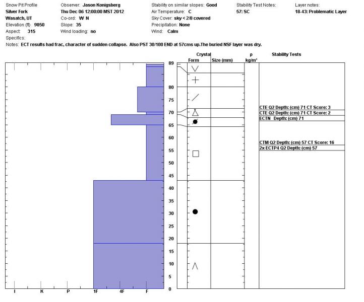
- <p>In general the rain and warm temperatures of late have added a lot of heat to the snowpack and eliminated the temperature gradient in the layer of facets that were buried on Dec. 2nd. In many places the facets are moist and rounding except above 9500ft (or maybe a little higher). </p>
Tried to get a handle on the distribution of the rain crust but it was very varied. It was up to an inch thick on one westerly facing slope at 9500ft (see picture below) and paper thin in other areas.
Snowpack
- Instability Comment
- <p>The areas of concern are above 9500ft on NW through NE where there wasn't much or any rain and the facet layer is still dry and capped by a wind crust. The faceted snow is still capable of propagating fractures (see attached snowpit) but isn't overloaded at this time. The dense snow above this layer is now a 30cm slab in isolated areas. Didn't venture into higher alpine terrain (like LCC ridgeline) but in wind loaded areas the weak layer may be overloaded.</p>
Above 9500 ft 3-5"of new snow. Bonded well to previous new snow at upper elevations. Between 9000-9500ft 1-3" of snow overlying rain crust. Rain crust thickness varied greatly from an inch thick to a fragile paper thin crust.