
Quick report
- Aspect
- Southwest
- Red Flags
- Recent Avalanches, Poor Snowpack Structure
- Elevation
- 3048 m
- Slope Angle
- 31°
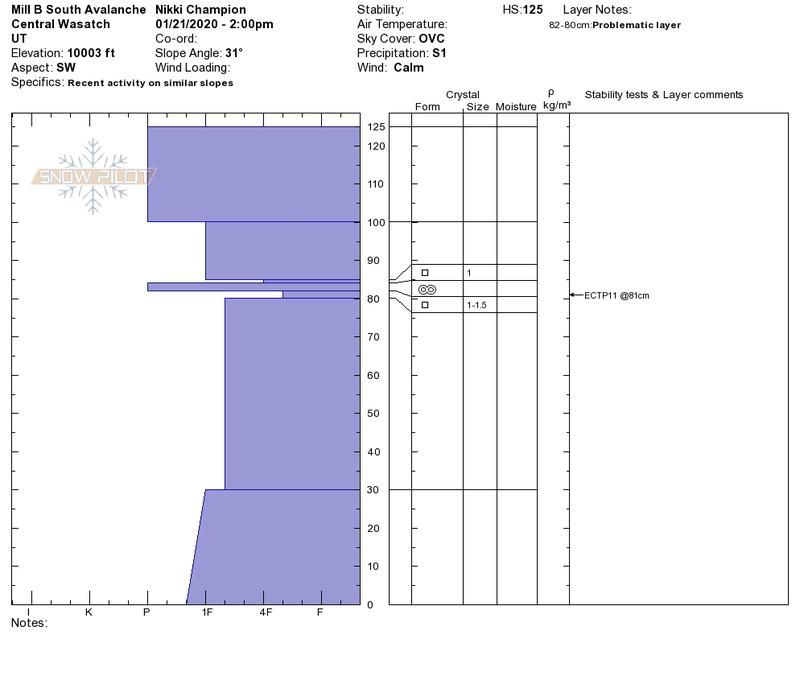
Photos of the crown profile and an ECT performed above the crown.
Low visibility view of the avalanche and debris.
Low visibility day.
Video states aspect is Southeast - aspect is actually West Southwest.
Snowpack
- Instability Comment
- <p>We headed out to investigate a <a href="https://utahavalanchecenter.org/avalanche/50596">recent avalanche in Upper South Mill B</a>, while visibility was completely obscured and we weren't able to grasp the entire extent of this avalanche we were able to find the debris and investigate a crown. What we found were two parallel crowns, one about 200' feet above the other. The upper crown was hard to see, but closely followed a rock band and was most likely a slab of wind drifted snow. What was interesting was the lower crown, this lower crown had stepped down into older snow. When we investigated the crown profile and bed surface, we found the failure plane to be the same crust and facet interface from between Christmas and New Years. There was 2mm crust, with facets (1-1.5mm) both above and below the crust. When the avalanche stepped down it appeared to fail on the layer of facets directly below the crust. </p> <p> </p> <p>When further investigating this layer we were able to get propagation, in that exact layer on the 11th tap of the shovel. We were investigating this layer directly above the second crown, so on top of the initial bed surface - not the entire snowpack as a whole, so this needs to be taken into account.</p> <p> </p> <p>While we haven't seen any other activity on this layer recently, this proves that this poor snowpack structure is still out there. It might not give off obvious signs of instability, such as cracking and whomping, but the instability exists. It is becoming harder to trigger, but situations such as avalanches stepping down hold the potential for this layer to be triggered again. It takes a very specific recipe, but certain outlier, steep slopes still hold the potential.</p> <p> </p> <p>East to the south to west-facing slopes MUST be investigated independently to determine if and where this layer exists. </p>
A variety of snow surfaces out there today, with the continued precipitation throughout the tour we probably picked up about 2" of warm, wet snow.
On any south-facing aspect there was a stout melt-freeze crust and signs of scoured wind crust in more solar protected areas.
Aspects on the north end of the compass still held onto some dense soft snow, but everything was getting damp by the afternoon.
Photo of new damp snow sticking to the bottom of skins.