
Quick report
- Aspect
- Northeast
- Red Flags
- Cracking, Collapsing, Poor Snowpack Structure
- Elevation
- 2743 m
- Slope Angle
- 25°
- Red Flags Comment
- <p>2 large collapses, I was surprised there were not more. Lots of cracking during last storm, see photos below. None today. Poor snowpack structure, nothing new here.</p>
HS=44", not bad for a weak winter.
2 mm basal facets, rounding but loose (fist)
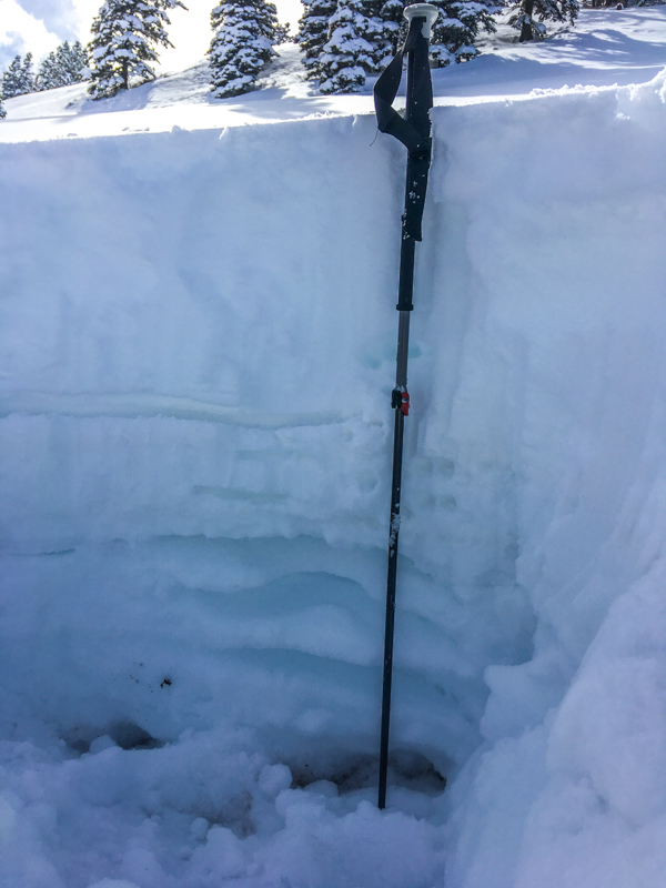
The mid pack consist of alternating crust (wind/warm?) and rounding facets 1 mm and less. The upper pack is sitting on a suncrust (uppermost horizontal line), facets at the base of this crust (ECTP 15, Q1.5, it had a nice pop on release).
One micro crust in upper pack which consists of recent storms.
Photo below ECTP, pole points to failure plane.
Photos below, activity from last storm on Monday.
1. 8,000, on approach, this reminds me while I backed out of coming here Monday, the summer trail crosses some steep terrian that I typically do not worry about. Slope is 37-40 degrees. sunny aspect
2. Gully below summer trail, shady aspect 8,000' elevations.
3. Main meadow I skied near pit location, this collapse did not run due to slope angle 25-30 degrees. The whole meadow was completely cracked with transverse cracks. and some additional collapse areas.
4. Cracks just below ridge, 9,200'.
Overall, all activity I saw (a lot) was all in the new snow and look like it happened during the storm which had some high PI rates.
If anyone wants to get in touch with me about snow/avalanche questions in SW Utah, I can be reached at [email protected]. I would be happy to walk anyone through the observation process. All observations are appreciated.
Overall I would say a considerable hazard, I traveled very cautiously and avoided my typical exit for this area which contains some steep slopes.
Snowpack
- Instability Comment
- <p>Today I was most concerned with the new snow. However, persistent slabs was not far behind.</p> <p>There is enough new snow sitting on some weak surfaces to warrent cuation.</p> <p>Considerable danger.</p> <p>Facets in the lower pack as well as a weak mid-pack are a significant concern with the new weight.</p> <p>Considerable hazard.</p>
HST=16" from last storm on Monday.
Trail breaking was hard, as Seth Shaw would say "a two sandwich day"