
Quick report
- Aspect
- Northwest
- Red Flags
- Heavy Snowfall
- Elevation
- 3048 m
- Slope Angle
- 29°
- Red Flags Comment
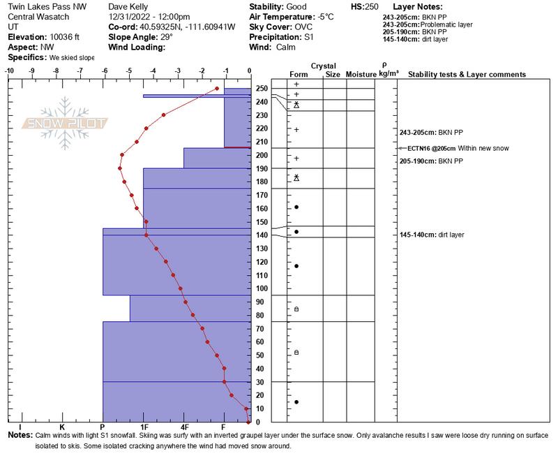
- <p>Last night's storm measured up 8-10" of new snow and 1" of water weight with another 2-3" of snow and .2-.3" of water falling since the observations were submitted this morning. Snow was surfy with a slightly inverted graupel layer that was soft and breakable. </p>
Snowpack
- Instability Comment
- <p>I went looking for the persistent weak layer PWL and found a very deep snowpack with temperatures showing a rounding PWL in this location. The trend in this location is decreasing. I would expect to find thinner snowpack areas where the PWL is still present at this elevation on steeper west-south-east aspects with lower height of snow. </p> <p>The new snow was running as loose dry avalanches isolated to skis on slopes approaching 30 degrees on this graupel layer. I did not see any results where it broke below this layer where I traveled. I avoided slopes greater than 30 degrees and traveled on ridgetops. </p> <p> </p> <p>With the forecast I would continue to look for increased precipitation rates and be wary of times when new snow has overloaded any of the density changes in the top of the snowpack. There are places where this additional weight<a href="https://avalanche.org/avalanche-encyclopedia/#snow-water-equivalent-swe"> (snow water equivalent)</a> of the new snow could be enough to break down into the November PWL layer. I saw some remants of loose dry activity on steeper (40 degree) east facing slopes headed back towards Twin Lakes. These likely ran in the new snow during periods of increased precipitation.</p> <p> </p>
15" new snow overnight. Old snow surface was still new snow from last storm. About 2.5' of settled new snow before you got into rounding snow in this location. New snow falling was broken precipitation particles