
Quick report
- Aspect
- Northwest
- Red Flags
- Wind Loading, Poor Snowpack Structure
- Elevation
- 2408 m
- Slope Angle
- 10°
- Red Flags Comment
- <p>Moderate rates of snow transport from moderate to strong NNW winds were observed above 7500ft, leading to active loading on SW-S-SE-E aspects and stripping along the opposite half of the compass through the morning and afternoon. Poor structure was found along northern half of compass above 7500ft, however we observed signs of PWL strengthening among mid-elevation, northern slopes.</p>
A windy and variable day, pockets of good snow linger but it's certainly variable. Took today as another opportunity to track our looming PWL within the mid-elevations of Cutler Ridge.
Snowpack
- Instability Comment
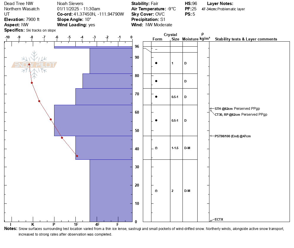
- <p>Along Cutler Ridge, HS averaged between 80-130cm - deepest on NW-N-NE aspects. The PWL was found 50-70cm down, resting beneath a well consolidated/settled 4F trending P hard slab consisting of the snow that fell late Dec into early Jan. We went out to target the PWL, it's current state and trend. We found that the overall structure from 7200-8000ft along northerly aspects is continuing to slowly stabilize, however the poor structure and faceted grains still exist. Faceted grains are showing increased signs of rounding, with an increase in moisture as well. Furthermore, test scores showed promising results, however this one just one pit location amongst the forecast area. The strong over weak set-up still exists, and the likeihood of triggering an avalanche at this interface may be lowering, yet the destructive potential still remains large and hazardous. We arent out of the woods yet! See snowpilot below. </p> <p>With 2-5cm of new snow overnight into today and moderate to strong northerly winds above 7500ft - snow was actively loading leeward slopes and micro terrain features. Within the mid-elevations, wind drifted snow had formed pockets ranging from 10-20cm thick at surface, however the connectivity was very inconsistent. Above 8000ft, one could surmise that these wind-drifted slabs are far more connected, are thicker/harder and have a higher ability to fail at the weight of skier/rider. The forecast for this morning certainly verified, as winds were swirling, and previously wind-drifted snow remained present. See photo of Ben Lomond peak, and drifting snow heading south at ridgeline at approx. 1000 this morning.</p>