
Quick report
- Aspect
- Northwest
- Red Flags
- Heavy Snowfall, Wind Loading, Cracking, Collapsing, Poor Snowpack Structure
- Elevation
- 2713 m
- Slope Angle
- 32°
- Red Flags Comment
- <p>Only had one good audible collapse and cracking was fairly minor. The amount of new snow and water weight as well as the wind were the biggest red flags. </p>
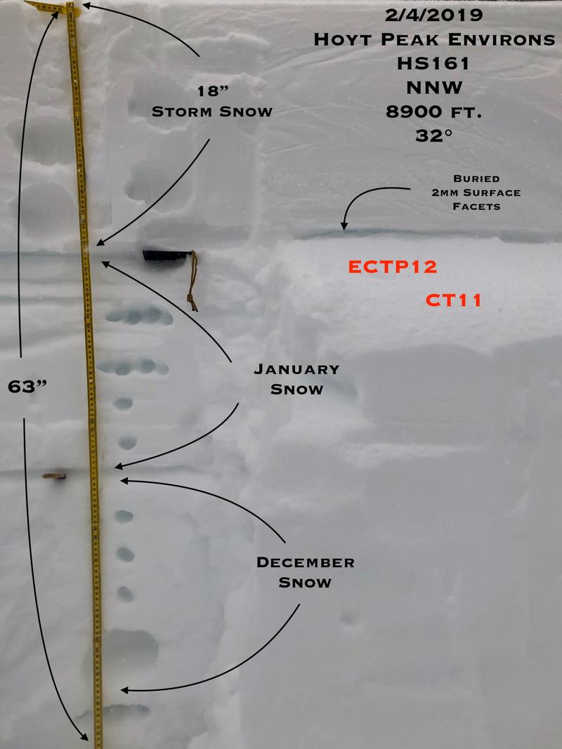
Only traveled to 9K and there was more snow than I had anticipated with around 2 inches of water weight. The surface facets from the end of January were not bonding well with the new storm snow. These grains are well preserved and are 2mm in size in the pit I dug. This layer will take some time to stabilize, which won't be anytime soon. I was curious to find the deeper persistent weaknesses were not reactive in ECT's. This being said, I still would be respectful of these weaknesses; a slide breaking in the January or December snow would be catastrophic. The new snow/old snow interface failed with easy to easy/medium effort with clean, planar shears. I did find one weakness in the new snow about 8" down on a density inversion.
Trailbreaking and snowmobiling were relatively easy and supportable considering the amount of new snow we received. Wintry conditions today.
The strong winds and amount of water weight we've gotten in the last 36 hours are enough to make me step back and take note but with MORE wind and snow expected, it's pretty obvious it's not the time to push it. Tomorrow, considerable danger in steep, mid elevation terrain and high danger at and above treeline, especially in terrain on the north half of the compass. Tread lightly.
Snowpack
- Instability Comment
- <p>I'm not sure whether to call this new snow or persistent weak layer. The new snow/old snow interface is going to be our new problematic persistent weak layer. The old faceted snow surface this storm fell on is weak and produced clean shear with easy to medium effort to fail and a propensity to shear across extended columns. The deeper persistent weak layers didn't react in extended column tests and were stubborn to fail in column tests. Those weaknesses are still there, I just didn't get any major feedback from them today. Increasing danger with more snow and wind expected. </p> <p>While not a big issue where I was today, the winds have been cranking since the storm started and just before. Winds have been strong from the SSE, S and SW. If you are traveling in the wind zone on the lee of these aspects you are most certainly in the high probability category for avalanches. It's just not even worth being in the wind zone right now, you're asking for nothing but trouble. More snow, more wind, increasing danger. </p>
Surfy, dense new storm snow. The upper one to two inches was relatively light. Damp snow surface to about 8K and damp snow under the new snow to about 8K as well.