Bollettino valanghe

Northwest Mountains

Crested Butte Avalanche Center
Vedi sulla mappa

Pericolo valanghe

Wed
Alta quota
4 · Forte
Limite del bosco
4 · Forte
Sotto il limite
4 · Forte
Non aggiornato — questo bollettino è scaduto 5 years ago. Stai vedendo condizioni passate, non il bollettino in corso.

In sintesi

An Avalanche Warning is in effect.  One to two feet of new snow is building on mega storm totals since Christmas Eve.  All of the new snow is overloading buried weak layers near the bottom of the snowpack. Very large and destructive avalanches are likely to release naturally today, and you can easily trigger them from on or below steep terrain.   Even small terrain features or steep slopes near town can produce large avalanches.   Low angle terrain (less than 30 degrees) without overhead hazards is the ticket today.   Traveling in or below avalanche terrain is not recommended.    


Problemi valanghivi

  • Storm Slabs

    • Alta quota
    • Limite del bosco
    • Sotto il limite del bosco
    Probabilità
    Very Likely
    Dimensione
    1.5–2.5

    Upwards of 2 feet of new snow and gusty winds are creating widespread instabilities in the upper snowpack.   Slabs will be larger and more sensitive in wind drifted terrain.  New snow instabilities are easier to recognize: you are likely to see cracking in the snow or get feedback on steep terrain.  However, any moving snow in the upper snowpack could step down and trigger a larger persistent slab.  You can avoid triggering storm slabs by riding on slopes less than 30 degrees.  


    An example of an avalanche earlier this season, that propagated widely below a wind-loaded ridgeline.  

  • Persistent Slabs

    • Alta quota
    • Limite del bosco
    • Sotto il limite del bosco
    Probabilità
    Likely
    Dimensione
    2.5–4

    Large and destructive avalanches are sensitive to human triggers and are likely to fail naturally.  Dangerous avalanches are breaking 5 feet thick or more on weak layers in the bottom of the snowpack,  and can run long distances.    Persistent slabs are most common on northerly and easterly aspects, where these buried weak layers are most fragile and slabs are more widespread. We've expanded the rose to include south to west aspects where there may be potential for crusts near the bottom of the snowpack to collapse. Given how thick these slabs are, you may not observe any obvious signs of instability. For example, two large avalanches were human triggered on Mt Emmons on Saturday; neither group reported any warning signs, such as collapses or shooting cracks.  

    A persistent slab triggered from a low angle ridgeline on Red Lady Glades. The slide broke 3 to 4 feet deep and ran far.

Avalanche Discussion

This video gives a brief snowpack history and context as to why avalanche conditions are dangerous right now.   In the past 24 hours, we've picked up about 10" to 20" of snow (up to 2.1" SWE) with another 3" to 10" expected today.   Winds were strong enough to drift snow all night.   A storm recap and weather forecast details are in our weather tab.  High Danger is tracking as expected and a WARNING is in place.  A lull in snow loading will cause a short-lived downturn in danger on Wednesday before the Thursday to Friday system looks to spike the danger through the roof.  

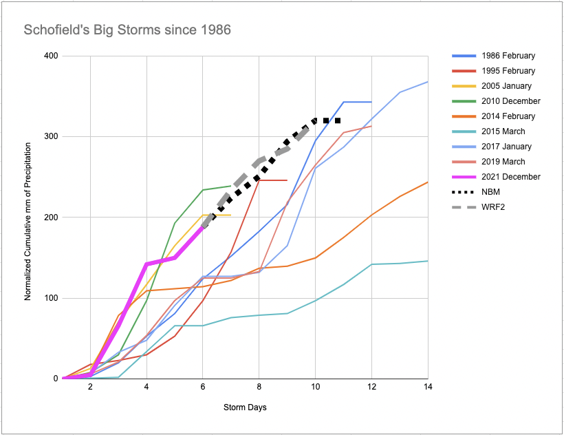
Let's put this prolonged loading event into historical context.  This graphic  (produced yesterday afternoon, before last night's storm) shows the biggest storms to strike Schofield Pass Snotel since its installation in 1986.  Most of these events produced extreme avalanche danger and/or historic avalanches.  As of yesterday afternoon, when we issued yet another Avalanche Warning, Schofield Pass's snow numbers were tracking on a more intense curve, just not to the prolonged extent yet.  The dotted lines show the modeled snowfall into the next several days.  After last night's snowfall, we are tracking past the low end of these historic storms and chugging along towards a top 3 ranking by New Years.  There are a lot of ingredients that go into producing a historic cycle, such as existing snowpack depth, structure and the loading patterns of the major storm.  The fact that we're thinking about this stuff should be alarming.  The volume of snow in start zones and tracks continues to increase, as does the expected size and runout distance of natural avalanches.  I've only forecasted through a few of these types of events; the odd thing about them is that the closer you get to historic-sized slides, the less feedback the snowpack provides.   It gets eerie quiet.  Weak layers get buried so deeply that they don't produce the common signs such as collapses or cracking that we are used to seeing during typical High or Considerable danger days, and visibility gets obscured so we don't see ongoing naturals. Yesterday, in a shallower part of our forecast area, Eric and I were lucky enough to experience a couple of rumbling collapses that sounded like jet engines. It was the most startling collapse I've ever witnessed.   Persistent slab instabilities may not be as widespread or as obvious as earlier in the cycle, but they are deadlier.  Even if those layers aren't talking to you, they are under significant stress right now.  Two inches of snow water equivalent equates to 300  tons across the dimensions of a football field, not counting wind loading.  That’s a dramatic load to suddenly add to an avalanche starting zone.     Long story short, give runouts a wider margin than you might expect today, even if the snowpack feels quiet.    

And let's not forget about roof avalanches.  They're no joke right now.   During our last mega storm two years ago, we saw numerous roof avalanche burials, one of which had a tragic ending.  Remind your kids not to play under roofs, and keep your wits about you while you're shoveling or leaving the house.    


Regioni coperte