

Bollettino valanghe

Ogden

Utah Avalanche Center
Vedi sulla mappa

Pericolo valanghe

  • Alta quota
  • Limite del bosco
  • Sotto il limite del bosco
Non aggiornato — questo bollettino è scaduto 3 years ago. Stai vedendo condizioni passate, non il bollettino in corso.

In sintesi

The avalanche danger is MODERATE where human-triggered avalanches are possible on all aspects and elevations.

Avalanches may fail within fresh snow or wind-drifted snow, 6-12" deep, but larger avalanches failing 2-6 feet deep are also possible.

Problemi valanghivi

  • Wind Slabs

    • Alta quota
    • Limite del bosco
    • Sotto il limite del bosco
    Probabilità
    Possible
    Dimensione
    4

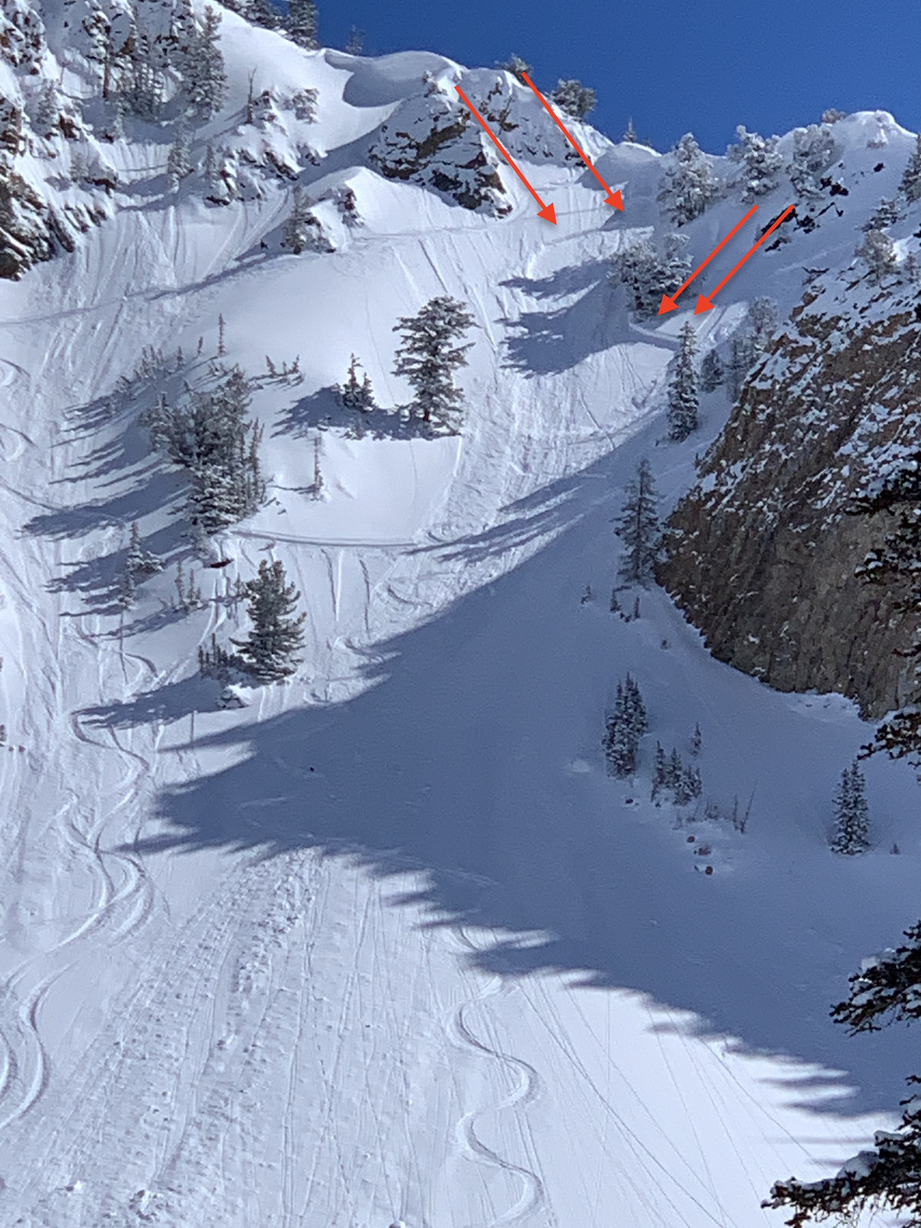
    Today's westerly winds will have new snow to work with and create fresh slabs of wind-drifted snow 6-12" deep. These wind drifts will be sensitive on northerly aspects if they form on top of the few inches of weak, low-density snow that fell overnight Wednesday.

    Additionally, strong winds and heavy snowfall this past week created hard slabs of wind-drifted snow on many slopes. These drifts are now buried underneath new snow and are no longer visible. Although field observations indicate these wind drifts are stabilizing, any avalanche involving this heavy load of snow could fail 2-5' deep.

  • Storm Slabs

    • Alta quota
    • Limite del bosco
    • Sotto il limite del bosco
    Probabilità
    Possible
    Dimensione
    3

    New snowfall from this past week totaled over 6' containing over 6" of water weight. This type of loading event will find any buried weak layer as evidenced byThursday's three reported avalanches that failed on a weak layer within or underneath recent storm snow.

    Although today's snowfall totals should be light, short bursts of intense snowfall are possible, especially this morning. The new snow may be reactive during any period of higher precipitation intensity, with shallow sensitive slabs or long-running sluffs.

Special Announcement

To help you safely enjoy the backcountry, the UAC team is constantly evaluating and implementing new programs and technologies. Donate to the Spring Campaign to help our team implement innovative tools and better provide you with the information you rely on.

Utah Snowmobile Association's 6th annual RALLY IN THE VALLEY, Saturday, March 4th at the cabins at Bear River Lodge. Bring family and friends to join in the fun!

Recent Activity

No avalanches were reported from the Ogden mountains on Thursday. To our south in the Salt Lake mountains, three avalanches were reported from Thursday, all on northwest aspects at about 10,000':

  • I unintentionally triggered an avalanche 2' deep and 60' wide that failed on facets in steep, rocky terrain in Hideaway Park.

  • Holy Toledo ~2' deep. Possibly wind-loaded. Trigger unknown.
  • Control work in unskied terrain at a Cottonwood resort pulled out a hard slab avalanche 5' deep and 100' wide.

The avalanche in northern Utah that keeps my attention occurred on Tuesday on the backside of Beaver Mountain. The slide was 2' deep and 600' on an east aspect at 8,000'. UAC forecasters Paige Pagnucco and Toby Weed visited the site on Wednesday:

Snow and Weather

This Morning: Winds are from the west/northwest and have increased overnight, gusting into the teens and upper 20's mph at the mid and upper elevations. Temperatures range through the mid-teens F.

Today: Snow will develop early this morning, with short periods of heavy snow possible through about mid-day, before turning showery this afternoon. Snowfall totals of 2-4" are expected by later today. Winds will be westerly, averaging in the teens with gusts in the upper 20's mph through the mid and upper elevations. Temperatures will reach the low to mid 20's F.

This Weekend: Snowfall increases Saturday afternoon and into Sunday, with 1-2' of snowfall possible by later Sunday. Additional snow is likely through much of this upcoming week.

Thursday's sunshine left a crust on many sunny slopes, with soft, dry snow on northerly slopes.

Total snowfall since last week is impressive (and that's saying something this winter)!

  • Upper Cottonwoods 68-79" snow (5.1-5.8" water)
  • Park City Ridgeline 54-60" snow (3.6" water)
  • Ogden area mountains 64-73" snow (5.8-6.6" water)
  • Provo area mountains 59-82" snow (5.3-6.8" water)

Additional Info

Forecaster Note: Most winters, any low-elevation snow is often considered less dangerous. However, with a deep snowpack down to 6,000', you must treat the low elevations no differently than you would the mid and upper elevations. These three avalanches stand out in that they all occurred in low elevation easy to access terrain that you can see from highways and neighborhoods: (1) Craig's video discussing a low elevation avalanche in Browns Canyon; (2) Drew's video discussing an avalanche in the Salt Lake Foothills, and (3) JB's report from the Ogden Foothills. These are the types of slides that can impact people with little knowledge of avalanche terrain. Please share this information with your friends who may not regularly read the avalanche report.

General Announcements

CLICK HERE FOR MORE GENERAL INFO AND FAQ

This information does not apply to developed ski areas or highways where avalanche control is normally done. This forecast is from the U.S.D.A. Forest Service, which is solely responsible for its content. This forecast describes general avalanche conditions and local variations always occur.

Observations and Avalanches

Backcountry Emergency Procedures

Instagram

Facebook

Get Forecast Email

Previous Forecasts

Contact via email

Submit Observation

Regioni coperte