

Bollettino valanghe

Salt Lake

Utah Avalanche Center
Vedi sulla mappa

Pericolo valanghe

  • Alta quota
  • Limite del bosco
  • Sotto il limite del bosco
Non aggiornato — questo bollettino è scaduto 4 years ago. Stai vedendo condizioni passate, non il bollettino in corso.

In sintesi

Dangerous avalanche conditions exist! The avalanche danger is CONSIDERABLE on all upper-elevation aspects and mid and lower-elevation aspects facing northwest through north and east where triggering deadly avalanches is likely. The avalanche danger is MODERATE on west-south-southeast aspects where triggering avalanches is possible.

I do not recommend traveling on, below, or adjacent to slopes 30 degrees or steeper on aspects facing northwest through north and east - including low and mid elevations.

There were three serious avalanche accidents involving significant injuries this past week and I am fearful our luck has run out. Safer alternatives exist outside of avalanche terrain with excellent riding on low angled slopes.

Problemi valanghivi

  • Persistent Slabs

    • Alta quota
    • Limite del bosco
    • Sotto il limite del bosco
    Probabilità
    Likely
    Dimensione
    3

    There is weak, sugary faceted snow (a persistent weak layer, or PWL) on almost all aspects and elevations throughout the Wasatch Range. This PWL has been buried by several feet of storm snow and wind-drifted snow which has created dangerous avalanche conditions, with three serious avalanche accidents this past week. This PWL is especially dangerous on aspects facing northwest through north and east - particularly at low and mid elevations - where triggering avalanches is likely.

    Although avalanches involving this PWL are less likely on solar aspects facing west through south, there is too much uncertainty given the amount of snow we have received this past week and avalanches failing in this PWL are still possible.

    I will not go anywhere close to a slope approaching 30 degrees or steeper on aspects facing west through north and east at any elevation. Fortunately, as this week's snowfall settles out, there is fantastic riding and travel conditions on low-angled slopes less than 30 degrees in steepness.

  • Wind Slabs

    • Alta quota
    • Limite del bosco
    • Sotto il limite del bosco
    Probabilità
    Likely
    Dimensione
    2

    Northwest winds Thursday and overnight into Friday morning have had plenty of low-density snow to blow around and you are likely to find sensitive slabs of wind-drifted snow at the upper elevations. The avalanche in Snake Creek on Thursday likely failed due to recent wind loading and there were other reports of sensitive wind drifts from Thursday.

    Any wind slab avalanche that you trigger has the potential to step down into deeper weak layers in the snowpack, creating a very large and dangerous avalanche.

    Look for evidence of fresh drifts and wind slabs that look wavy, rounded, smooth, and pillowy, and avoid those slopes. Signs of sensitive wind-drifted snow include cracking (photo Engel).

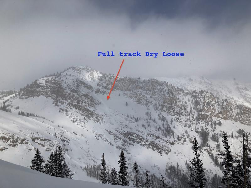
    Although any new snow instabilities have likely settled out, long-running sluffs are still possible in the cold, dry snow.

Special Avalanche Bulletin

DANGEROUS AND UNUSUAL AVALANCHE CONDITIONS WILL LAST THROUGH AT LEAST THIS WEEKEND. HEAVY SNOWFALL THIS PAST WEEK HAS CREATED DANGEROUS AVALANCHE CONDITIONS AT ALL ELEVATIONS. DON'T BE LURED BY THE BEAUTIFUL SUNNY SKIES AND FRESH POWDER INTO THINKING AVALANCHE CONDITIONS ARE SAFE WHEN THEY ARE NOT.

DO NOT TRAVEL ON, UNDERNEATH, OR ADJACENT TO SLOPES 30 DEGREES OR STEEPER ON SLOPES FACING NORTHWEST, NORTH, NORTHEAST, AND EAST WHERE TRIGGERING LARGE AND DANGEROUS AVALANCHES IS LIKELY. THIS INCLUDES LOW-ELEVATION FOOTHILLS WHERE AVALANCHES CAN OCCUR NOT FAR FROM PARKING AREAS AND TRAILHEADS.

Special Announcement

Park City Mountain Resort is planning on opening the Jupiter Lift area this weekend. Please avoid the Scott's and Pinecone areas for the rest of the season.

Recent Activity

Drew has published a blog "Dangerous and Unusual Avalanche Conditions" describing the avalanche activity over this past week.

The were reports of sensitive wind drifts on Thursday, including a large natural avalanche in Snake Creek on an east aspect at 9,200'. The slope appeared to be wind-loaded from the sustained northwest winds on Thursday and estimated at several hundred feet wide and a crown 1-2' deep.

There were three serious avalanche accidents this past week with serious injuries with two that required rescues. The avalanches broke down over 2' deep into the layer of November facets. These avalanches occurred at low elevations below 8,000':

Tuesday - Pink Pine Ridge 7,800' North-facing 2-3' deep, 60' wide. Read the preliminary report. UAC staff visited the area on Wednesday, but due to avalanche danger, chose not to approach the actual avalanche:

Wednesday- Thomas Fork in Neffs Canyon 7,200' North-facing 2' deep 200' wide. Read the preliminary report.

Aerial image of the Neff's Canyon crown and burial site.

Friday, December 9, an avalanche accident on Santaquin Peak in the Provo mountains that failed in the persistent weak layer of faceted snow also involved serious injuries. The avalanche was 1-2' deep and 600' wide.

There were other avalanches this past week that occurred at low elevations below 8,000, including Lambs Canyon, Daly Canyon, and Summit Park.

Check out all the avalanches HERE and if you see an avalanche, please report it.

Snow and Weather

Temperatures this morning are a few degrees below zero F with partly-cloudy skies. Winds are from the northwest with gusts in the teens mph at mid-elevations and 20's mph at upper-most elevations.

Snowfall totals since Sunday night include:

  • Cottonwoods: 2.5' - 6' snow containing 1.5" - 2.75" SWE (snow water equivalent)
  • Park City: 1.5' - 3' snow containing 1" - 1.5" water SWE

For today, partly-cloudy skies with temperatures in the high single digits. Winds will be from the northwest with gusts in the teens at mid elevations and upper 20's mph at the upper elevations.

For this weekend, sunshine and cold temperatures with a chance for a return to unsettled weather by mid-week.

Get caught up in significant weather and avalanche activity over this past week by reading our Week in Review.

Additional Info

Mark Staples has also written a season summary HERE.

General Announcements

CLICK HERE FOR MORE GENERAL INFO AND FAQ

This information does not apply to developed ski areas or highways where avalanche control is normally done. This forecast is from the U.S.D.A. Forest Service, which is solely responsible for its content. This forecast describes general avalanche conditions and local variations always occur.

Observations and Avalanches

Backcountry Emergency Procedures

Instagram

Facebook

Get Forecast Email

Previous Forecasts

Contact via email

Submit Observation

Regioni coperte