Bollettino valanghe

Salt Lake

Utah Avalanche Center
Vedi sulla mappa

Pericolo valanghe

  • Alta quota
  • Limite del bosco
  • Sotto il limite del bosco
Non aggiornato — questo bollettino è scaduto 4 years ago. Stai vedendo condizioni passate, non il bollettino in corso.

In sintesi

Areas of CONSIDERABLE avalanche danger exist on steep aspects facing west to north to east at all elevations. Avalanches may be 2-4' deep, well over a hundred feet wide and may be triggered remotely (from a distance).

A MODERATE danger exists at the mid and upper elevations for shallow wind drifts and lingering instabilities within the storm snow including sluffing and soft slabs of new snow.

Expect small loose, wet avalanches on east, south, and west aspects due to warming from strong sunshine.

Sunday's dense storm snow will provide safer and superb riding conditions on lower-angled slopes - just make sure there is nothing steep above you.

Problemi valanghivi

  • Persistent Slabs

    • Alta quota
    • Limite del bosco
    • Sotto il limite del bosco
    Probabilità
    Likely
    Dimensione
    3

    Many large and dangerous human-triggered avalanches have occurred over the past several days, failing on a layer of faceted snow (a persistent weak layer, or PWL) that formed during the January/February drought. Avalanches failing on this PWL are 2-4' deep and well over 100' wide. The PWL can be found at all elevations on slopes facing west through north and east.

    On Sunday, we added 0.4" to 0.9" of water with some wind-loading to this inherently dangerous snowpack structure.

    A few additional notes of caution:

    • Signs of instability may not always be present: you may or may not see or experience shooting cracks or audible collapsing.
    • Tracks on the slope offer zero signs of stability. Avalanches can take out multiple existing tracks.
    • You can trigger these avalanches remotely - from a distance or from below.
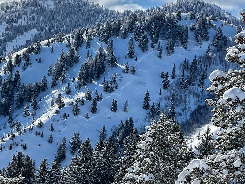
    • Many avalanches have occurred at lower elevations below 8,000' such as this natural avalanche in Lamb's Canyon.

    The good news is that Sunday's dense snow will provide safer and superb riding conditions on lower-angled slopes with nothing steeper above you.


  • Wind Slabs

    • Alta quota
    • Limite del bosco
    • Sotto il limite del bosco
    Probabilità
    Possible
    Dimensione
    2

    Pockets of fresh wind drifted snow can be found at the upper elevations - especially aspects facing northwest through east - as well as mid-elevation slopes in exposed/open terrain. Cracking in these dense slabs of wind-drifted snow are an indication they are sensitive.

  • Storm Slabs

    • Alta quota
    • Limite del bosco
    • Sotto il limite del bosco
    Probabilità
    Possible
    Dimensione
    1

    Instabilities within Sunday's storm snow should rapidly settle out today, but you may still find pockets of sensitive soft slabs 3-6" deep as well as sluffing on steep slopes. The fresh snow will also likely become reactive to today's sunshine, with loose wet avalanches on aspects facing east, south, and west.

Recent Activity

No backcountry avalanches reported from Sunday. Patrollers at ski resorts were finding sluffing in the storm snow and soft slabs 3-6" thick.

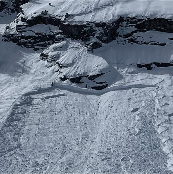
Over the past few days we have had a few near misses and my honest assessment is we've been lucky. This includes a full burial 6' deep in Silver Fork on Saturday (photo below). Rescuers recovered the skier after a 23 minute burial, but fortunately breathing. In addition to the companion rescuers, thanks to the efforts of rescuers from SL County SAR, WBR, Solitude and Snowbird ski patrol teams, Powderbird, Life Flight, and others. Read the preliminary report.

Other recent - but not nearly all - avalanches include:

- East Mineral

- Silver Fork

- Mat's Basin

Look through all recent observations and avalanches.

Read Drew's new blog post about accidents, "Deus Ex Machina".

Snow and Weather

Skies are partly cloudy and temperatures are in the low to mid teens F. Winds are from the northwest and were moderate to strong through about midnight with gusts in the 20's and 30's mph at mid elevations and over 60 mph at the upper elevations. Winds have since relaxed and are now gusting in the teens at mid elevations and in the 20's at the upper elevations.

Snowfall totals since Sunday morning are generally 2-7" containing up to a half inch of SWE (snow water equivalent) but Big Cottonwood Canyon fared quite well with up to a foot of new snow with nearly an inch of SWE.

Partly cloudy skies this morning will give way to a mostly sunny afternoon. Temperatures will rise into the upper 20's through mid 30's. Winds will be from the northwest, averaging in the teens with gusts near 20 at mid elevations and into the 20's at upper elevations.

A decent refresh beginning late Tuesday with 3-6" expected snowfall.

Additional Info

Blog on "Our Jan/Feb Drought Layer and PWL Summary of Avalanche Activity on This Layering for the Central Wasatch Range." HERE.

General Announcements

Who's up for some free avalanche training? Get a refresher, become better prepared for an upcoming avalanche class, or just boost your skills. Go to https://learn.kbyg.org/ and scroll down to Step 2 for a series of interactive online avalanche courses produced by the UAC.

CLICK HERE FOR MORE GENERAL INFO AND FAQ

This information does not apply to developed ski areas or highways where avalanche control is normally done. This forecast is from the U.S.D.A. Forest Service, which is solely responsible for its content. This forecast describes general avalanche conditions and local variations always occur.

Observations and Avalanches

Backcountry Emergency Procedures

Instagram

Facebook

Get Forecast Email

Previous Forecasts

Contact via email

Submit Observation

Regioni coperte