
Salt Lake
Danger d’avalanche
- Alpin
- Limite forestière
- Sous la limite forestière
Points saillants
The overall avalanche danger remains LOW. Normal Caution is advised.
Today you'll be able to trigger both wet and dry loose snow sluffs on the southerly and northerly aspects, respectively. Any dry loose sluff may gouge into older faceted snow, leaving larger debris piles. Along the highest elevations, you may encounter scattershot shallow and soft wind slabs in lee terrain.
Special Announcement
New essay by UAC Director Paige Pagnucco - Weak Snow: Today’s Surface, Tomorrow’s Avalanche Problem
Recent Activity
Ski areas noted very shallow, pockety wind slabs up high and some longer running loose dry sluffs that gouged into the exceptionally weak surface facets. Of note: whereas these loose dry "facet" sluffs just to be just big enough to knock you off your feet, now they are almost large enough to bury you.
Snow and Weather
Skies are clear under a building full moon, christened the Snow Moon. We'll have 13 full moons in 2026.
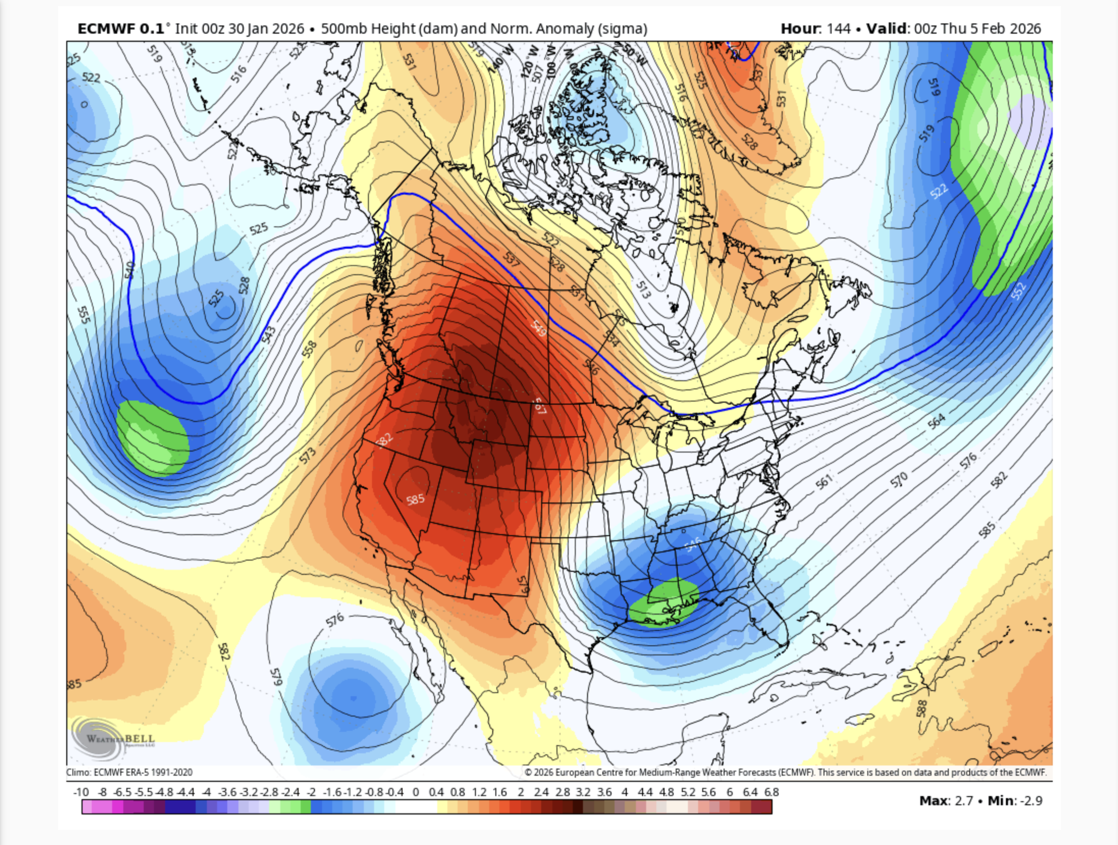
Mountain temperatures are in the teens; winds from the northwest are 10-15mph with gusts to 20. At 11k, winds are 20-25mph with gusts to 35. For today, we'll have mostly sunny skies, light to moderate winds from the northwest and temperatures warming into the mid-20s up high, the mid-30s down low. The weather outlook remains fairly grim, with not one but two blocking patterns setting up to swat away any potential storms. Not all is lost, however; I am seeing some hints of a pattern shift in the second week of February, though possibly more toward Valentine's Day. In geologic terms, it's just a blink of an eye.
Riding conditions are much improved with Wednesday night's couple-few inches of snow. It's a good time to explore: forecasters toured around Timpanogos and Deseret Peak yesterday.
❄️
The Week in Review is hot off the press!
Additional Info
Forecaster's Corner:
Thirty years ago: One of the more significant avalanche cycles in recent history. Early winter 1995 was fairly dry in the Wasatch, only to be clobbered by 16' of snow in 16 days in the latter part of January. It led to an amazing avalanche cycle: the Argenta slide path off Kessler Peak hit Big Cottonwood Canyon road; the West Porter avalanche path cleared tons of trees and dusted the cabins in Porter Fork; and at 1AM on January 31st, the Bridal Veil slide path above Provo Canyon avalanched, completely destroying the tourist tram base terminal...crossed the Provo River and the open road, and continued uphill a few hundred yards on the other side. ! (See UAC Annual Report 1995-96) It was my first season as an avalanche professional in the Wasatch; and I'm thinking, Does this happen every winter?!?
Photo: Mike Olson, Darwin Stoneman, and Tom Carruthers (Powderbird guides hired for explosive avalanche work from helicopter) big game hunting in the Argenta slide path (with Argenta the dog). I believe the upper photo is UDOT forecaster Greg Dollhausen (Argenta's owner) inspecting the crown. Argenta was the name of the small logging/mining 'town' wiped out by an avalanche in that location in the late 1800s.
General Announcements
This information does not apply to developed ski areas or highways where avalanche control is normally done. This forecast is from the U.S.D.A. Forest Service, which is solely responsible for its content. This forecast describes general avalanche conditions and local variations always occur.