Bulletin d’avalanche

Ogden

Utah Avalanche Center
Voir sur la carte

Danger d’avalanche

  • Alpin
  • Limite forestière
  • Sous la limite forestière
Périmé — ce bulletin a expiré 3 years ago. Vous consultez des conditions passées, pas le bulletin en cours.

Points saillants

Areas of CONSIDERABLE danger still exist for wet avalanches on many aspects and elevations. Today's cold front will only mask any wet unconsolidated snow below. I will admit to a great deal of Uncertainty with today's forecast, but I would continue to avoid steep terrain until we see a few days with a proper refreeze.

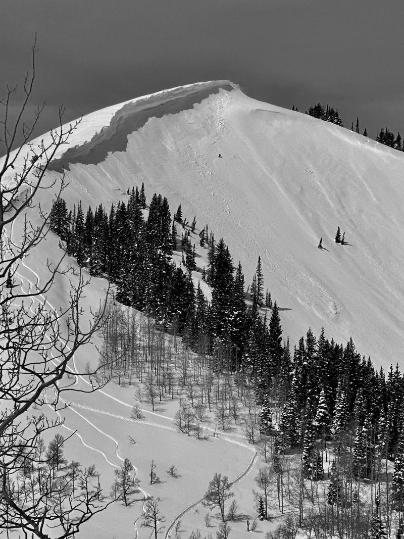
Cornices and roof-alanches present a real danger today. Glide avalanches remain very likely in steep terrain with glide cracks.

Problèmes avalancheux

  • Cornices

    • Alpin
    • Limite forestière
    • Sous la limite forestière
    Probabilité
    Likely
    Taille
    3

    Huge cornices are sensitive to warming temperatures and strong winds and can trigger an avalanche on the slope below.

    Historically, cornice fall has resulted in the death of 6 individuals in Utah since 1940.

  • Loose Wet

    • Alpin
    • Limite forestière
    • Sous la limite forestière
    Probabilité
    Possible
    Taille
    3

    I have to start this with capital 'U' Uncertainty. Forecasting wet avalanches can be like reading the tea leaves.

    The Good: On one hand, observed runnels (wavy undulations) on the snow and water rushing down the sides of the road hint at good "plumbing" within the snowpack. Our snowpack is not that structured with crusts and coarser layers.

    The Bad: On the other hand, most areas haven't seen a decent refreeze since the weekend...and the strong winds and cloud cover hampered any radiational cooling that might have been. All this conspires to produce melt water that percolates through the snowpack. If and when this water finds a crust or coarser layer in the snow, it avalanches. Sometimes.

    The Ugly: You're looking at it. I think the skiing and riding today will be rough and rugged, especially if there is a dust layer or developing crust on the snow. Still time to do your taxes.

    Travel Advice: If you're sinking up to your shins or bogging down on the machine...or hear any collapsing, then immediately move to low angle terrain.

    Large wet avalanche debris that overran the Rock Canyon trail in Provo on Tuesday morning with a similar event in Adams Canyon above Layton on Monday.

  • Glide Cracks

    • Alpin
    • Limite forestière
    • Sous la limite forestière
    Probabilité
    Very Likely
    Taille
    4

    Glide avalanches are extremely dangerous and destructive as the entire season's snow avalanches to the ground. Continued warm temperatures and water greasing rocky bed surfaces have opened up glide cracks throughout the range. One full depth glide avalanche on the Raymond slabs in Porter Fork of Mill Creek released Tuesday. Glide avalanches will still continue to be active through the weekend, despite today's cold front.

    I would avoid traveling in areas known for glide avalanches like Chilly Peak and the north side of Willard Peak. We have had accidents and fatalities involving Glide Avalanches in the past.

    April 28, 2001

    Feb 10, 2013

Special Announcement

The final UAC report for the Upper Weber Canyon avalanche accident on March 9 has been published and is available HERE. The UAC would like to thank Park City Powder Cats for sharing information about the timeline of the accident and allowing UAC staff access to the avalanche after the incident.

Join Snowbasin Ski Patrol at their Annual Dog Fundraiser 630PM on Saturday April 15th at the Union Grill. See the flyer below.

Recent Activity

None yesterday.

Snow and Weather

Skies are mostly cloudy with cool air on the way.

And we're desperate for it (even though the cold front will offer only an inch or two of snow), as overnight temps are again in the upper 30s to low 40s. Many areas haven't seen a decent refreeze since last weekend (see Wildcat@7700' graph below)

Southwest winds have been relentless, blowing 25mph with gusts to 35. I will be interested to see if we have a dust layer from this wind event.

This morning's cold front will drop temperatures to the teens and winds will shift to the northwest and lose quite a bit of steam.

Cool and cloudy Friday with gradual clearing and a warming trend through early next week. Perhaps another storm for mid-week?

General Announcements

CLICK HERE FOR MORE GENERAL INFO AND FAQ

This information does not apply to developed ski areas or highways where avalanche control is normally done. This forecast is from the U.S.D.A. Forest Service, which is solely responsible for its content. This forecast describes general avalanche conditions and local variations always occur.

Observations and Avalanches

Backcountry Emergency Procedures

Instagram

Facebook

Get Forecast Email

Previous Forecasts

Contact via email

Submit Observation

Régions couvertes