

Avalanche forecast

Gunnison

Crested Butte Avalanche Center
View on map

Avalanche danger

Tue
Alpine
1 · Low
Treeline
1 · Low
Below
1 · Low
Out of date — this forecast expired 4 years ago. You’re viewing past conditions, not the current bulletin.

Highlights

The avalanche danger is LOW today rising to MODERATE tonight.  The snowpack is generally stable, and triggering an avalanche is unlikely today.   Any lingering problems through the day are most likely to be found on northerly facing terrain at upper elevations in very steep, rocky, or unsupported terrain.  The danger will start rising later this afternoon or overnight as increasing winds begin transporting snow into fresh wind slabs at higher elevations.    Blowing snow will clue you into changing conditions. 

Avalanche problems

  • Persistent Slabs

    • Alpine
    • Treeline
    • Below treeline
    Likelihood
    Unlikely
    Size
    1.5–2

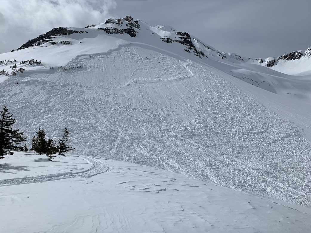
     Slab avalanches breaking into old weak layers several feet deep have become unlikely, but not impossible.  Higher elevation, northerly facing terrain still holds a dry, winterlike snowpack; thus we can't completely eliminate the potential for a rare but large slab avalanche on these aspects.  The most suspect terrain is convex or unsupported slopes, especially near rock bands. You are most likely to trigger a slide from a shallower spot on the slope.  If you are skiing or riding in that type of terrain, reduce your group's exposure during uphill travel and choose appropriate safe zones from a large avalanche while descending.  Let your friend wrestle their stuck snowmobile off of suspect slopes by themselves.  

    Example of a persistent slab avalanche that likely failed last week.  The avalanche highlights the type of terrain that is most worrisome:  northerly, rocky, and unsupported.  
Avalanche Discussion

It's been about two months since our last LOW danger day. I'll start with a reminder that LOW danger means that avalanche conditions are generally safe, but isolated instabilities can exist.  Even a thin wind drift or small sluff in serious terrain can have high consequences.  The avalanche danger is expected to start increasing this evening and through the day tomorrow as a strong wind event accompanied by new snow forms a fresh round of sensitive wind slabs.  Tomorrow's danger will depend on how much snow we pull out of this system: if we see the high end of snowfall forecasts, it could rise to CONSIDERABLE at upper elevations by the end of the day.

Today's avalanche concerns are isolated and difficult to trigger.  We saw significant wind slab instabilities develop last week, caused by a foot or more of new snow and strong winds.  With warm and mild weather over the past few days, those wind slabs have generally healed.  This afternoon's increasing winds will have limited snow available for transport, but I suspect we'll see some cross drifting and thin wind slabs starting to form on northerly aspects where the snow surfaces are still dry.  Look for drifting or blowing snow to alert you to changing conditions.

If you've followed along with our forecasts this winter, you know that we have a well-developed weak layer that raged into action in late February, and continued to produce large avalanches into the first two weeks of March.  Since mid-March, our forecast area has only seen two dry persistent slabs fail on old layers (Example A, Example B), while bordering regions in the Aspen Zone and North San Juans have been more active in recent weeks.  The dramatic warmup late in March flushed meltwater into the snowpack on all but northerly aspects, thus transitioning the snowpack on west, south, and east aspects into a trustworthy spring snowpack.  Given the isolated persistent slab avalanche activity and lack of signs of instability over the past few weeks, it's clear that the odds of triggering a persistent slab within our forecast area are quite low, but not zero.

End of season party! Join us at the Talk of the Town Friday, April 8 from 6-10 p.m. as we wish to say thank you to all of our sponsors, supporters, and the community at large. We will have complimentary Modelo beer for everyone, live music from Congo Turner & Company, and a free raffle.

Regions covered