Avalanche forecast

Ogden

Utah Avalanche Center
View on map

Avalanche danger

  • Alpine
  • Treeline
  • Below treeline
Out of date — this forecast expired 7 years ago. You’re viewing past conditions, not the current bulletin.

Highlights

The UAC has issued an AVALANCHE WARNING for the Ogden mountains. The avalanche hazard is HIGH at the upper elevations, and CONSIDERABLE at the mid and low elevations, where strong winds and heavy snowfall have created dangerous avalanche conditions. At the low elevations, wet avalanches are possible due to rain and warm temperatures.

Avoid being on or underneath slopes any steeper than 30 degrees, and avoid avalanche runout zones. Travel in avalanche terrain is NOT recommended.

Avalanche problems

  • Storm Slabs

    • Alpine
    • Treeline
    • Below treeline
    Likelihood
    Likely
    Size
    2

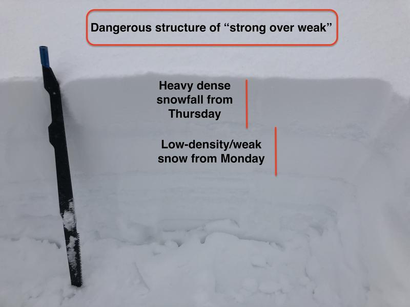
    Very heavy and dense snowfall that began early Thursday morning fell on top of very light/weak snowfall from earlier this week, instantly creating a dangerous structure of a strong slab over weaker snow. Additional snowfall today will only further stress the snowpack.

    Watch for signs of instability ("red flags") including avalanches, cracking (photo below), and collapsing.


  • Wind Slabs

    • Alpine
    • Treeline
    • Below treeline
    Likelihood
    Likely
    Size
    2

    Very strong winds out of the west at the mid and upper elevations will continue to create deep wind drifts on all aspects. Recent and fresh wind drifts will be most pronounced at the upper elevations, but you are also likely to find them in mid-elevation terrain as well.

    Although cracking is a sign of instability in wind-drifted snow, these dense drifts may not show their sensitivity so easily, and allow you to get well out onto a slope before fracturing widely.

  • Loose Wet

    • Alpine
    • Treeline
    • Below treeline
    Likelihood
    Likely
    Size
    2

    Warm temperatures and rain have saturated the top few feet of the snowpack in many locations. Watch for wet avalanches on steeper slopes, and avoid steep-sides gullies and terrain traps.

    The rain and warm temperatures are also causing many roofs to shed their snowpacks.

Avalanche Warning

IN EFFECT FROM 1 PM MST THURSDAY TO 6 AM MST SATURDAY

FOR THE MOUNTAINS OF NORTHERN UTAH INCLUDING THE WASATCH RANGE...BEAR RIVER RANGE...UINTA MOUNTAINS

THE AVALANCHE DANGER WILL BECOME HIGH ON MANY SLOPES AT DIFFERENT ELEVATIONS AND ASPECTS.

HEAVY DENSE SNOW AND WINDS UP TO 100 MPH HAVE CREATED CREATED WIDESPREAD AREAS OF UNSTABLE SNOW. BOTH HUMAN TRIGGERED AND NATURAL AVALANCHES ARE LIKELY. STAY OFF OF AND OUT FROM UNDER SLOPES STEEPER THAN 30 DEGREES.

Special Announcement

Discounted lift tickets - Thanks to the generous support of our Utah ski resorts and Ski Utah, all proceeds from these ticket sales go towards paying for avalanche forecasting and education! Get your tickets here. Looking to improve your avalanche skills? We are offering a Backcountry 101: Introduction to Avalanches class at Powder Mountain February 14-15.

Recent Activity

Sensitive wind drifts and storm slabs were reported from Thursday at mid and upper elevations. At lower elevations, warm temperatures and rain created natural wet avalanches, including these natural wet avalanches on highway 39 east of Ogden Canyon (observation)

Snow and Weather

Currently: Temperatures in the Ogden mountains range through the upper 20's and low 30's F. Winds are from the west, averaging in the teens with gusts in the 30's at mid elevations. Along upper elevation ridgelines winds are averaging in the 30's with gusts in the 50's mph. Overnight 2-4" of additional snowfall, with 24-hour totals of 4-8".

Rain was reported at lower elevations, as well as a riming event later Thursday afternoon at some locations.

Today: Expect temperatures to rise into the 20's and 30's and west/northwest winds will remain strong, gusting into the 30's at mid elevations, and 40's and 50's at the upper elevations. An additional 2-4" of snow is expected, with localized higher amounts possible.

General Announcements

CLICK HERE FOR MORE GENERAL INFO AND FAQ

This information does not apply to developed ski areas or highways where avalanche control is normally done. This forecast is from the U.S.D.A. Forest Service, which is solely responsible for its content. This forecast describes general avalanche conditions and local variations always occur.

Observations and Avalanches

Backcountry Emergency Procedures

Instagram

Facebook

Get Forecast Email

Previous Forecasts

Contact via email

Submit Observation

Regions covered