Avalanche forecast

Salt Lake

Utah Avalanche Center
View on map

Avalanche danger

  • Alpine
  • Treeline
  • Below treeline
Out of date — this forecast expired last year. You’re viewing past conditions, not the current bulletin.

Highlights

The avalanche danger is CONSIDERABLE on mid and upper-elevation slopes where human-triggered avalanches involving soft slabs of storm snow or wind-drifted snow are likely. Avalanches may fail 1 to 2 feet deep at one of the many storm snow interfaces or on some isolated upper-elevation northerly slopes, on a more-deeply buried persistent weak layer. The avalanche danger is MODERATE at low elevations.

Today will be a brilliant day and the low-density snow from overnight will offer superb riding conditions on slopes less steep than 30°.

Avalanche problems

  • Wind Slabs

    • Alpine
    • Treeline
    • Below treeline
    Likelihood
    Likely
    Size
    2

    Winds over the past 24 hours have drifted snow on all aspects, especially above 9,500'. This avalanche problem may be more subtle than usual: in field work yesterday, UAC forecasters noted even the slightest hint of wind-drifting created a sensitive soft slab. Watch for cracking as an indication of sensitive conditions.


  • Storm Slabs

    • Alpine
    • Treeline
    • Below treeline
    Likelihood
    Likely
    Size
    2

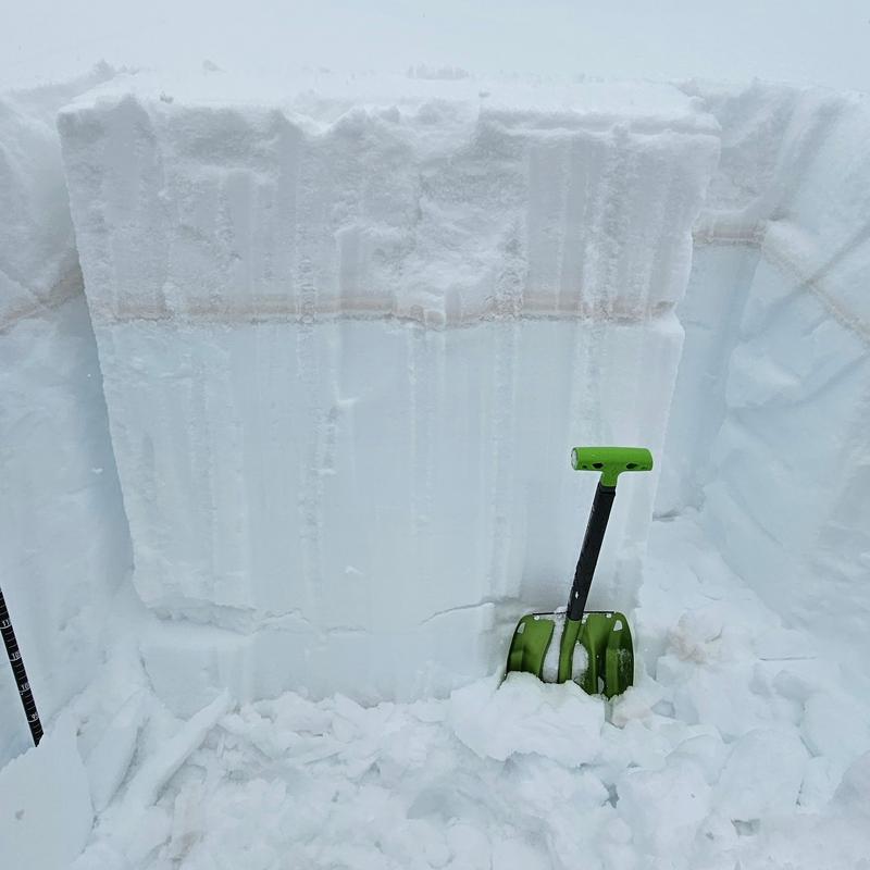
    Soft slabs of storm snow may be sensitive today, failing within one of many different density changes that exist in the 1-2 feet of the recent storm snow, as shown in the photo below from Nat Grainger. The low-density snow from overnight may also create long-running sluffs. Although snowfall is only expected to be showery today, natural avalanches may be possible during any period of heavy snowfall

  • Persistent Slabs

    • Alpine
    • Treeline
    • Below treeline
    Likelihood
    Possible
    Size
    3

    The 2-4 feet of snow (containing 2-4 inches of water) that has fallen this past week will ultimately help with our lingering persistent weak layer (PWL) problem, but for now, it has added a stress to the snowpack in areas where the PWL remains, notably repeater slopes that have avalanched more than once this season. Unless you have precise knowledge of the snowpack history on a particular slope, you can assume a steep, northerly-facing slope has probably avalanched this season. Another PWL to watch is a layer of faceted snow just underneath the dust layer that was buried on Monday.

Special Announcement

March kicks off our Spring Campaign! If everyone in Utah’s backcountry community donates the cost of something they regularly enjoy on an adventure—like a dawn patrol burrito, a backpack snack, or post-ride trailhead drinks—we could fund not just one but two forecasters for the entire season! Donate here. Thank you!

Recent Activity

Reported avalanche activity from the backcountry on Thursday included a skier-triggered avalanche in Yellowjacket in Millcreek on a wind-loaded, north-facing slope at 9,500' that ran 700' vertical. Nat Grainger has an excellent report from Cardiff and Days Forks where he saw natural sluffing and soft slabs (photo below), and a natural avalanche on Mars Hill above Lake Lacawaxen. These avalanches ran long distances and failed within recent storm snow interfaces, although snow safety teams from Cottonwood resorts also reported some avalanches that failed in the prominent dust layer that is now buried 2-3 feet deep.

Observations and Avalanches

Be sure to include Nikki's Week in Review as you plan your backcountry travels.

Snow and Weather

As of 5 am, temperatures are in the teens and winds are blowing from the west/northwest, gusting into the 30's mph at the highest elevations and 10-15 mph along exposed mid-elevation ridgelines. 3-6 inches of new snow has fallen overnight.

Snow/water totals since Wednesday:

Little Cottonwood: 20-26"/1.5-2.0"

Big Cottonwood: 12-18"/1.0-1.5"

Park City Ridgeline: 12-15"/1.0-1.4"

For today, expect light snow showers, with 2-4 inches of new snow possible. Temperatures will rise into the mid and upper 20's F and winds will be from the northwest and veering northerly, blowing 15-20 mph along exposed mid-elevation ridgelines and 30-35 mph at upper elevations.

March is our snowiest month and the upcoming weather forecast seems to support this. Sunny and warm this weekend, with an active storm pattern looking to return early next week.

General Announcements

CLICK HERE FOR MORE GENERAL INFO AND FAQ

This information does not apply to developed ski areas or highways where avalanche control is normally done. This forecast is from the U.S.D.A. Forest Service, which is solely responsible for its content. This forecast describes general avalanche conditions and local variations always occur.

Observations and Avalanches

Backcountry Emergency Procedures

SMS Notifications

Instagram

Facebook

Get Forecast Email

Previous Forecasts

Contact via email

Submit Observation

Regions covered