Avalanche forecast

Galena Summit & Eastern Mtns

Sawtooth Avalanche Center
View on map

Avalanche danger

Thu
Alpine
2 · Moderate
Treeline
2 · Moderate
Below
1 · Low
Out of date — this forecast expired 4 years ago. You’re viewing past conditions, not the current bulletin.

Highlights

You may be able to trigger avalanches in both wind-affected and sheltered terrain. In areas exposed to the wind, you could trigger hard or soft drifts or slabs that formed over the past several days. In areas more protected from the wind,  1-2 foot thick avalanches are possible on shady slopes facing E-N-W. Pay attention to the consequences of being caught in even small slides in terrain with rocks, cliffs, trees, and terrain traps.

Avalanche problems

  • Persistent Slabs

    • Alpine
    • Treeline
    • Below treeline
    Likelihood
    Possible
    Size
    1.5–2.5

    What is it?  We're faced with two distinct persistent slab scenarios:

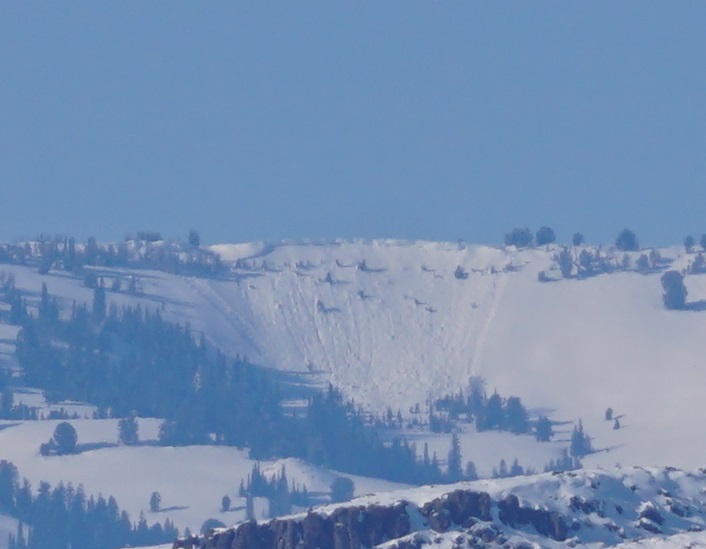
    1. Surface hoar: The most recent human-triggered avalanche occurred Sunday on a sparsely treed, sheltered slope near Titus Ridge on Galena Summit (see photo to right/above). The 1-2 foot thick avalanche failed on a buried layer of surface hoar on a N-NE aspect near 9100'. This weak layer remains capable of producing avalanches on some slopes steeper than about 35 degrees.
    2.  Older weak layers—crusts and/or facets, and spotty surface hoar—exist deeper in the snowpack. These are buried beneath dense, 2-4 foot thick slabs, making them difficult to trigger but capable of producing very dangerous avalanches.

    Where is it? 

    1. Thesurface hoar is most widespread and problematic in protected, middle-elevation terrain that faces E-N-W. Surface hoar is a tricky weak layer. It can be "spotty" in its distribution—it may exist on some slopes, but not others. You're more likely to encounter this problem in the northern and western portions of this zone. 
    2. The older, more deeply buried weak layers are most widespread, and suspect,  in rocky, wind-affected, alpine terrain in the White Cloud, Boulder, and Pioneer Mtns (photo, details) where snowpack depths are less than about 4 feet.

    How can you recognize it?  Assume the persistent slab issues exist until proven otherwise. You may or may not experience snowpack collapsing and/or cracking while traveling. These red flags are obvious signs of instability. The layer of surface hoar is subtle and may not "jump out at you" when searching for it in a snowpit (see photo here). Wind-swept, upper elevation slopes with thin, variable snowpack depths are likely to harbor the older crust and facet layers.          

    How can you manage it?  

    1. Buried surface hoar: You can reduce your risk by avoiding shady slopes (facing E-N-W) that are very steep (greater than about 35 degrees)—especially those with ugly consequences if you are caught in an avalanche. While the observed avalanche activity points to the layer being more common on sheltered slopes, don't rule out its existence in terrain exposed to the wind. These avalanches may break wider than expected or higher on the slope above you. 
    2. Older weak layers: Although not likely, you could trigger a  large slide on slopes steeper than about 35 degrees in rocky, wind-affected, alpine terrain. Slopes like these have variable snow depths, with thinner areas of the snowpack that allow us to impact deeper weak layers. You can reduce your risk by steering clear of large, recently wind-loaded avalanche paths that are peppered with rocks sticking up above the surface (photo), a great indicator of variable snowpack depths. 


    (1/30/2023) This 1-2 foot thick, skier-triggered avalanche failed on a layer of buried surface hoar. Surface hoar is frequently found in shady, partially treed locations like this. N-NE aspect near 9100' in the Salmon River drainage near Galena Summit.

  • Wind Slabs

    • Alpine
    • Treeline
    • Below treeline
    Likelihood
    Possible
    Size
    1–1.5

    What is it?  Last week's NW-N-NE winds formed 1-3 foot thick, hard and soft wind slabs in exposed terrain. Over the weekend, light snowfall and continued northerly winds formed a thinner, softer generation of wind slabs. Monday, we spotted a large, fairly recent wind slab avalanche in the Soldier Mtns (view photo here). While the wind slabs are becoming more difficult to trigger with each passing day, observers report widespread wind-affected snow surfaces throughout the forecast area. Reports of snowpack cracking are decreasing, but professionals continue to steer clear of recently formed wind slabs.

    Where is it?  Wind slabs are largest and most widespread near exposed ridges. You may find them near ridgelines, on the sides of gullies and chutes, and near prominent terrain features. 

    How can you recognize it?  Cracks shooting out from your skis or sled are an obvious sign of instability. Watch for drifts, dunes, and ripples on the snow surface. Wind slabs can have a smooth, chalky appearance and feel and sound hollow, like a drum. Wind-deposited snow will be stiffer and keep your skis or snowmobile closer to the surface.       

    How can you manage it?  The easy move is to avoid obviously wind-loaded avalanche terrain. Hard slab avalanches can behave unpredictably, breaking above skiers and riders. Any triggered wind slab could "step-down" to buried persistent weak layers (Problem 1) lower on slopes, causing a larger destructive avalanche.  

    (1/29/2023) This recent small wind slab released naturally on Titus Ridge near Galena Summit. It failed on a E/NE-facing slope at 9,600'.

Avalanche Discussion

Over the past month, we've seen a significant divergence in the character of the snowpack within and between forecast zones. In a broad sense, you can lump them into two categories: shallow and deep. Why does depth matter? Persistent weak layers tend to survive or thrive in shallow snowpacks. Where the snowpack is deeper, buried persistent weak layers tend to strengthen over time. The Galena Summit and Eastern Mtns Forecast Zone falls into the shallow category. 

Three to five feet of snow are on the ground in this zone. Weak layers buried in November and December are closer to the surface here, and triggering a slide involving these weak layers remains a possibility on slopes steeper than about 35 degrees where the wind has created a variably thick snowpack. The layer of surface hoar that was buried in early January hasn't seen as much of a load in this area and lacks a slab on many slopes. In most locations, you need the additional stiffness and weight from wind-loading for this layer to be a problem. However, Sunday's triggered avalanche near Galena Summit failed on a slope that is typically sheltered from the wind. 

On top of these weak layers, a few generations of wind slabs formed in the past week.  More snow fell in the northern portion of this zone (from Galena Summit and north into the White Clouds), and wind slabs should be larger and easier to trigger here. The most recently formed slabs are softer and may be more reactive to your weight. However, the large, recent slide in the Soldier Mtns probably involved rock-hard snow that drifted onto the slope last week; triggering beasts like that is a possibility. Triggered wind slabs can be effective triggers for deeper weak layers in the snowpack. 

The consequences of triggering avalanches can vary significantly. Triggering a small slide in terrain free of rocks, trees, and terrain traps is much less dangerous than triggering a slide in extreme, rocky, treed terrain with a terrain trap at the bottom. Think about the consequences of being caught in a slide before committing to skiing or riding in sizeable avalanche paths.

Regions covered