The alpine rating is considerable, the treeline rating is considerable, and the below treeline rating is moderate.
Known problems include Persistent Slabs.
The Bottom Line: Unusually dangerous conditions exist where snow and wind built slabs over a layer of buried surface hoar. If venturing out into the mountains, use extra caution near or below any open slope steeper than 30 degrees. Careful navigation and terrain selection is necessary for a safe day in the mountains.
Summary
Snow and Avalanche Discussion
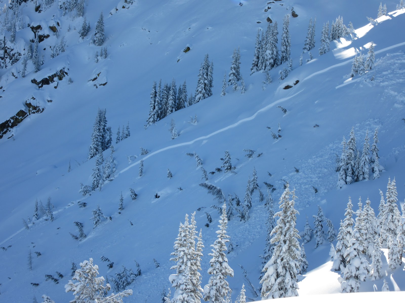
On the 31st an observer in the Icicle Creek drainage found the snowpack to be very reactive. A supportable rain crust was found up to about 5,500ft. The snowpack above the crust at low elevations had begun to facet out, and surface hoar was observed growing on top. As soon as he got above 6,000ft, where the trees were more sparse, cracks began shooting out from his skis as he walked along the ridge. Avalanches were triggered from a distance while walking on this ridge. These were on average 18" deep, and easily up to 400ft wide. As the slabs slid downhill, light reflected off the shiny bedsurface, it was large, feathery, surface hoar. A widespread natural avalanche cycle had occurred during the tail end of the storm, but some slides may have released well after the snow stopped falling. We do not know much about the distribution of this layer across the ranges of the eastern slope. However, we need to treat our upper elevation terrain as guilty until proven innocent.
This past storm brought 1.8” of water equivalent at the Sasse Ridge Snotel site in the Salmon la Sac drainage (which could equate to nearly two feet of snow at higher elevations), while further east Mission Ridge picked up just an inch or two of new snow, but with winds of over 100mph. This is likely creating a pronounced difference in avalanche danger between the western and eastern portion of the ranges.
Regional Synopsis
Happy New Year!
Thanks to all of you who volunteer, send observations, and support NWAC in various ways - we appreciate it.
December of 2018 was fun (from a forecasting perspective) with three pronounced avalanche cycles, a couple different persistent weak layers, some rain events, and a flurry of human triggered avalanches to ring in the New Year. Most importantly, it seems that we made it through the last days of 2018 without anyone getting seriously hurt by an avalanche.
The deep (Dec 9) layer responsible for many of the avalanches early in the month no longer seems to be a problem in the western zones. That said, it is still possible to trigger an avalanche on its counterpart (or basal facets) in the eastern areas.
A widespread layer of surface hoar formed around Christmas. Late December storms preserved this layer in areas above the rain line and we have numerous (more than a dozen) reports of people triggering avalanches on it in the last three days. At least 4 people were caught and carried during this period, but so far we have no reports of serious injury. Most of these avalanches were soft slabs, D1-D2+, but there were several harder wind slabs in the mix.
It appears that the layer is most reactive and/or prevalent in the Crystal Mountain backcountry and in the mountains around Leavenworth and west of Mazama.
Surface Hoar can be an especially tricky and persistent weak layer. Read more about it here.
Weather Forecast
Wed 2nd Jan 14:57
- Kenny Kramer
Weather Synopsis for Wednesday night through Friday
A Pacific front will spread increasing light precipitation to the Olympics and Mt Baker area Wednesday afternoon. The initial warm frontal moisture will be directed mainly across the north part of the forecast area overnight Wednesday. The heaviest precipitation will remain directed to the Mt Baker area Wednesday night, where it should become heavy.
Freezing levels rise rapidly overnight through early Thursday and peak Thursday morning along with continued heavy precipitation in the Mt Baker area with significantly less precipitation reaching the southern WA Cascades and Mt Hood area.
Thursday should be a very wet day, especially in the north part with little to no precipitation reaching the Mt Hood area.
Light easterly winds across the passes are not expected to save the Stevens and Snoqualmie areas from rain, as they often do throughout the winter.
The associated cold front finally crosses the Cascade crest Thursday night, maintaining moderate to heavy precipitation and extending precipitation to the remainder of the forecast area in the south.
Showers should continue to lowering freezing levels Friday as a weak upper trough passes the area. The Mt Baker area will continue to receive the greatest precipitation Friday, with gradually less towards the south.
Problems
Persistent Slabs
You can trigger dangerously large and surprising avalanches on slopes over 30 degrees. Avalanches may be more reactive and break wider than you can expect. You can trigger persistent slabs from a significant distance. You don’t even need to be on the slope to trigger them. Put plenty of space between you and any suspect avalanche terrain. Stay far away from slopes that roll to over 30 degrees, and make sure you are well out from under any overhead avalanche terrain.
In many parts of the zone, the latest storm has created slabs up to two feet thick that are resting on a layer of large, feathery surface hoar from Christmas. This low friction layer has been observed to be sitting on a firm, old snow surface above 5,500ft. It may be very easy to trigger avalanches on open slopes above this elevation, especially in places where the wind has helped to give cohesion to the snow near the surface. Avalanches may wrap widely around terrain features, and may initiate on low angle slopes. Steer clear of steep slopes if you suspect this layer has more than 8" of snow over it, as you may trigger slides from a distance and from below. Below mid 5,000ft range, a thick, supportable rain crust may help to inhibit any slides on this layer.