The alpine rating is considerable, the treeline rating is considerable, and the below treeline rating is moderate.
Known problems include Wind Slabs and Persistent Slabs.
The Bottom Line: The snowpack is complicated in the East Central Cascades. As more snow accumulates and the wind creates fresh drifts avalanche danger will rise. This is a good time to step back, and focus on finding terrain to recreate in that isn't steep enough to avalanche.
Summary
Snow and Avalanche Discussion
Up to 7” of snow fell in the zone on the 17th with light winds. The Wenatchee Mountains east of Highway 97 were the winner. This likely preserved the old snow surface that consisted of a mix of facets, crusts, and old wind packed snow. On Thursday an observer reported collapses on a crust/facet sandwich layer down about 12" on an East aspect at 5800ft near Blewett Pass, a sign that a previous persistent weak layer is beginning to groan under its new heavy blanket.
Prior to the recent storm cycle, observes reported 'dramatic faceting' near and below treeline on shaded aspects. Another speaks of skiing on a ‘glass carpet’ of surface hoar between 4,000 and 5,500ft. Folks spoke of facet sluffs, a sure sign of very weak snow. We anticipate that the new snow won’t bond well with this old surface. The Salmon la Sac and Teanaway, and upper Icicle Creek stand to do better from this next storm rolling through into Friday. As the winds pick up and the snow accumulates, this will set the stage for our next round of avalanche activity. Avalanche danger will likely reach High by Saturday with a strong storm coming in Friday night.
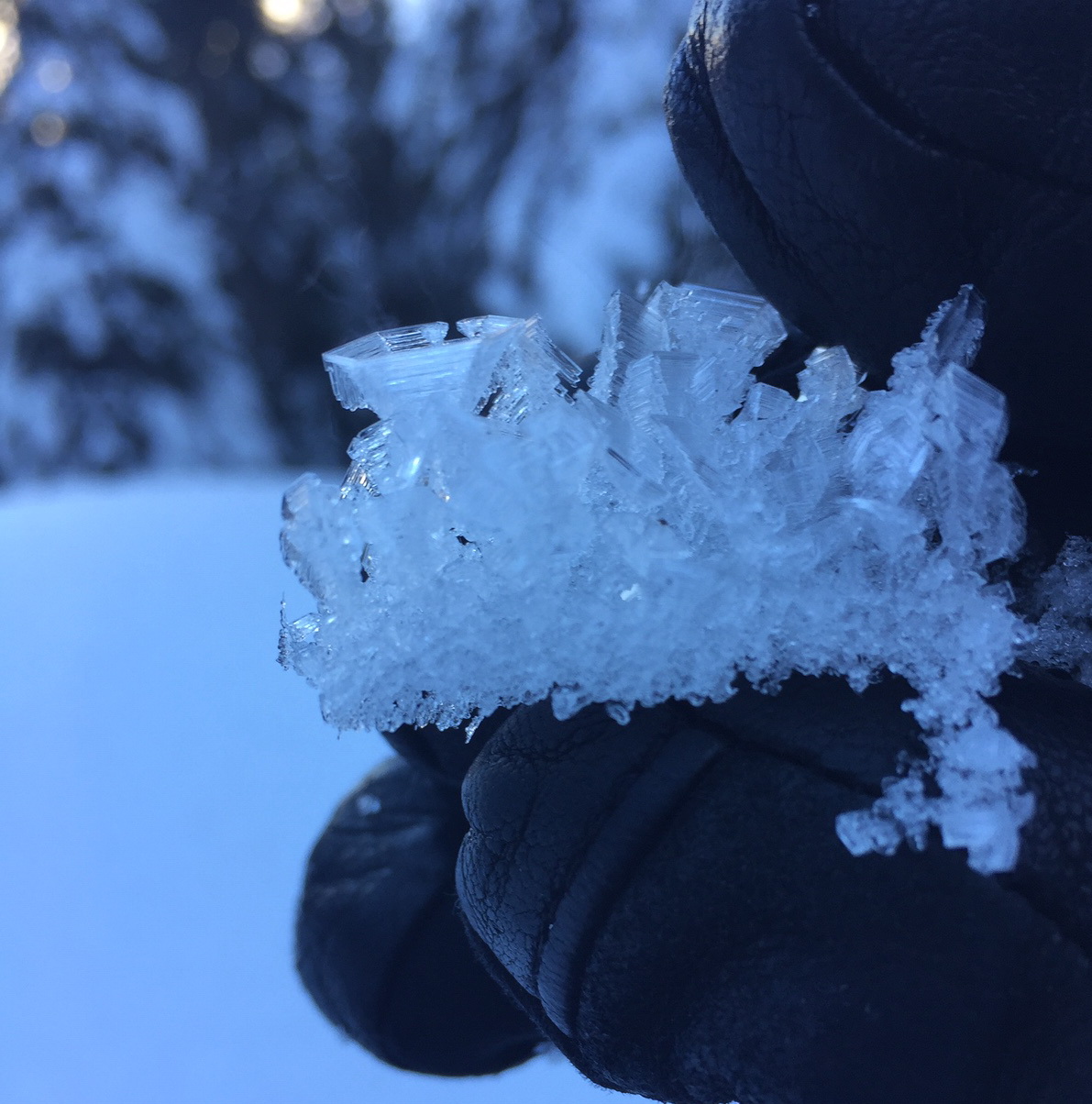
Large, cup shaped surface hoar found in Icicle Creek on 1/14
Weather Forecast
Fri 18th Jan 14:44
- Robert Hahn
Weather Synopsis for Friday night through Sunday
Although the Thursday night system didn't have as much moisture as anticipated, Friday night's storm will deliver. A powerful and deepening storm system tracking NE toward the Queen Charlotte Islands will pack a major punch Friday night. Heavy precipitation is arriving on the coastline late Friday afternoon as strong warm front lifts across the region, beginning late in the day. Overnight, moderate to heavy precipitation will slam the Cascades. Mt. Hood will likely be the winner in terms of precipitation with 2-2.5", while Mt. Rainier and Mt. Baker will be in the 1-1.5" range, with most other NWAC stations receiving 0.5-1" of moisture. The warm front will warm temperatures 15F as it crosses the coastline so many areas will see a changeover to rain, particularly during the late evening and overnight hours, before changing back to snow at some point on Saturday. Easterly flow may insulate the passes from the warming during the evening hours, but eventually, but atmosphere will be so warm aloft that Stevens and Snoqualmie may turn to all rain before the wind shift very early Saturday morning. The easterly flow is helping to bring significant water amounts east of the Cascade crest such as in the Mission Ridge and Leavenworth areas.
On Saturday, light to occasionally moderate snow shower activity will gradually diminish during the day, where narrow bands of precipitation may be locally intense. Saturday night, further diminishing snow showers will end after midnight. On Sunday, the front stalled over southern Oregon will lift some light moisture back into northern Oregon and southern Washington as a mild trough digs off the Oregon coast.
Regional Synopsis
Wed 16th Jan 09:00
January 16, 2019
Since Friday January 11, we’ve enjoyed a spell of generally nice weather in the mountains. This allowed for some great views, enjoyable outings, and lots of snow observations. A more active weather pattern beginning Thursday January 17th will bring this nice weather to a close.
During this time period, the snow surfaces around the area have changed dramatically. This forms the foundation for a few current trends we are seeing in the mountains.
New Snow Problems
Reports from around the area indicate a wide variety of snow surface conditions prior to new snow on January 17th. We’ve heard about breakable crust, very icy surfaces, sugar facets, surface hoar, and rime. What snow surface you encounter can depend on aspect, elevations, and general location.
As a series of winter storms impact the area, how will the new snow bond to the old snow surface. This can be tricky to predict. As the snow starts to pile up make lots of shallow snow observations. Shovel tilt test, hand shears, and small slope test can all help you track how the new snow is bonding to the old snow at different aspects and elevations. Stop and take a look at where the snow is failing. Do you see large grains of snow? Do they look like feathers? Do the act like sugar? How far below the current snow surface are they?
Old Snow Problems
There are still lingering persistent weak layers in the eastern zones of the cascades. You are most likely to find weak older snow in areas further east from the Cascade crest where snowpacks are shallower, more variable, and generally weaker. In some locations weak snow near the ground can still be found. These basal facets have hung around all season. The only way to gain information about these old persistent weak layers is to get out your shovel and dig. Because of the size of our forecast zones and the variability in the snowpack, it's important to make snow observations as you travel. We’ll keep watching these old layers, but let us know what you see while you are in the mountains.
Problems
Wind Slabs
The winds will pick up on Friday after a mostly calm day. These, combined with a burst of new snow will form dense slabs, increasing the avalanche danger. Anticipate that these slabs won’t bond well with the old, weak snow surface that recently got buried. When you find more than 6” of new snow has drifted in or accumulated, it’s time to evaluate for slab characteristics. Look for shooting cracks within the new snow. Check how the new snow is bonding by using small, inconsequential test slopes and quick hand pits. Is there strong over weak? Is the new snow cohesive enough to crack? If so, it is time to avoid slopes steep enough to avalanche.
Aspects:
All aspects.
Elevations:
Alpine, Treeline.
Likelihood
Likely
Expected Size
2 - 2
Persistent Slabs
Even if you are competent at evaluating and navigating through avalanche country, the complexities and intricacies of the snowpack are not to be taken lightly. The snowpack east of Highway 97 in the Wenatchee Mountains is substantially more shallow and weak than areas further west. Persistent slabs are a very real concern here, and in any area on the eastern edge of the range where less than 4 feet of snow is on the ground near treeline. Further west, the main layer of concern will be the new snow interface with the old snow surface.
Another layer of concern is associated with the January 3rd crust which can be found from 12” to 24” down. In the Wenatchee Mountains, this looks more like a pair of thin, friable, freezing rain crusts. Surface hoar and facets are sandwiched above, between, and below. In most places further west, the crust is supportable, but small facets can be found above this crust. Avalanches were observed on this layer as recently as January 12th starting on east aspects at 7000ft.
Finally, there is weak snow near the ground, particularly near the eastern edge of the forecast zone. If an avalanche failed on the ground, it would take the entire seasons snowpack with it, creating a very large and destructive slide. Be aware that this layer may begin to awaken with this new load, especially heading into the weekend.