The alpine rating is considerable, the treeline rating is moderate, and the below treeline rating is moderate.
Known problems include Wind Slabs and Persistent Slabs.
The Bottom Line: Even though the avalanche danger is slowly dropping you will still need to be heads-up Thursday. You may trigger avalanches in areas where the wind has formed firm slabs or in locations where weak old snow layers exist. You can stay safe by avoiding slopes greater than 35 degrees.
Summary
Snowpack and Avalanche Discussion
We have quite a bit of uncertainty around the weather forecast for the next 24 hrs. Weather models are struggling to determine freezing levels and precipitation amounts. This will add another layer of variability to an already variable snowpack in the East-Central zone. When conditions like this exist, it’s a good time to be heads-up. Is what you are seeing inline with the avalanche forecast? If not, stop and reevaluate. In general areas closure to the Cascade crest may exhibit features closer to snowpacks of Stevens and Snoqualmie Passes. Further east a much weaker and more complex snowpack exists.
Weather Forecast
Thu 10th Jan 14:31
- Robert Hahn
Weather Synopsis for Thursday night through Saturday
The Pacific Northwest will be quite mild at the end of this prolonged period of warm generally southerly flow which has scoured out the cold air pool east of the Cascade Crest. Meanwhile, a ridge is amplifying across the Inter-mountain West, pushing out the last moisture from the moist southerly flow during the early evening hours. The ridge diverts storms to the north and south of our region. It will also re-amplify the pressure gradient across the Cascades, setting up a prolonged pattern of moderate easterly flow. Inversion conditions will also develop, leaving a shallow pool of cold air in the deeper valleys east of the Cascade Crest. This low cloud will likely stream through the lower Cascade passes.
The Freezing level will climb to 7000 ft or higher in many locations west of the Cascade Crest Friday through Saturday. Expect cooler temperature through the pass and on the east slopes with the inversion conditions in place.
Regional Synopsis
Mon 7th Jan 09:00
January 7, 2019
This latest round of storms in early January continues to highlight some of this season’s region-wide themes in our snowpack. I’d describe them as Bottom to Top, North to South, and East to West. Let’s take a look at each of these.
Bottom to Top:
In general this winter has been on the warm side in the Cascades. No where is that more evident than in the lack of low elevation snow. Heavy rain events continue to wash-away and thoroughly wet the lower elevation snowpack. In most regions you will see substantial increase is the height of snow from low elevations (3000 ft), to mid elevations (4500 ft), and again at upper elevations (5500/6000 ft). Above the typical rain lines (5000-6000 ft) a deep and cold mid-winter snowpack exists.
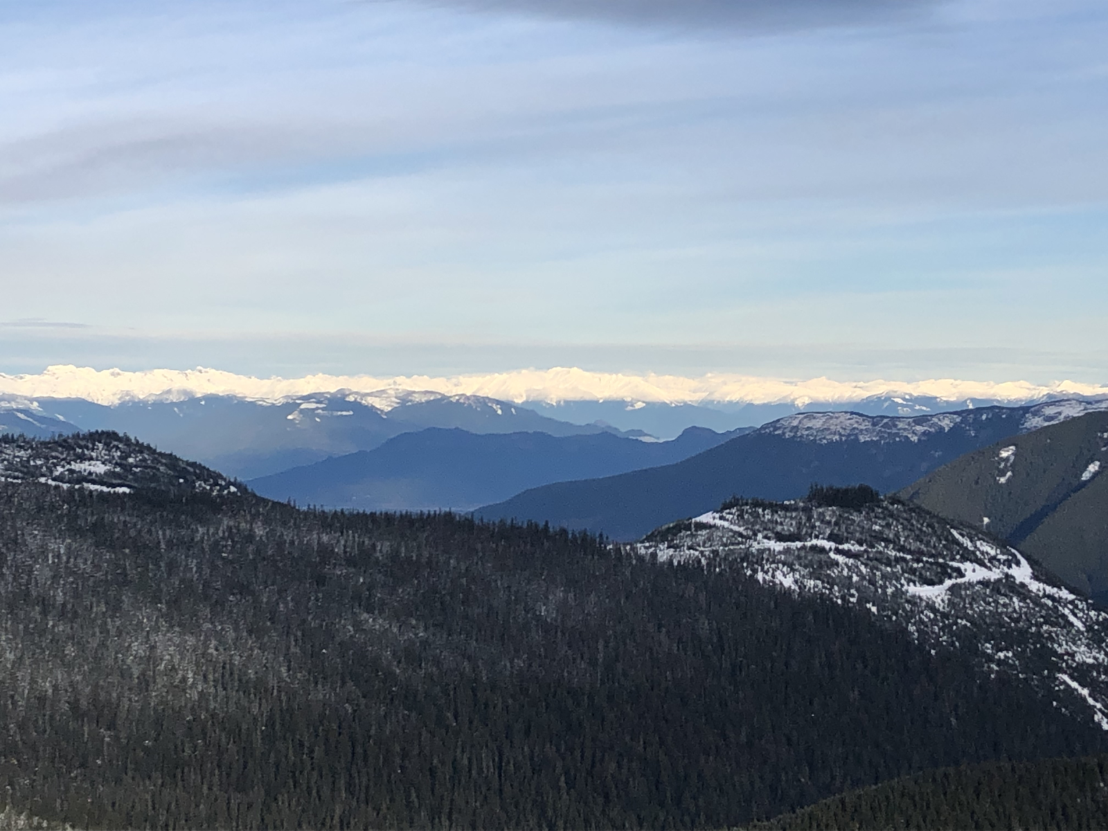
Jan 5, 2019: The dark timber in the Coast Range highlights the thin snowpack at lower elevations and the deeper winter-like snowpacks near and above treeline: Photo: Simon Trautman
North to South:
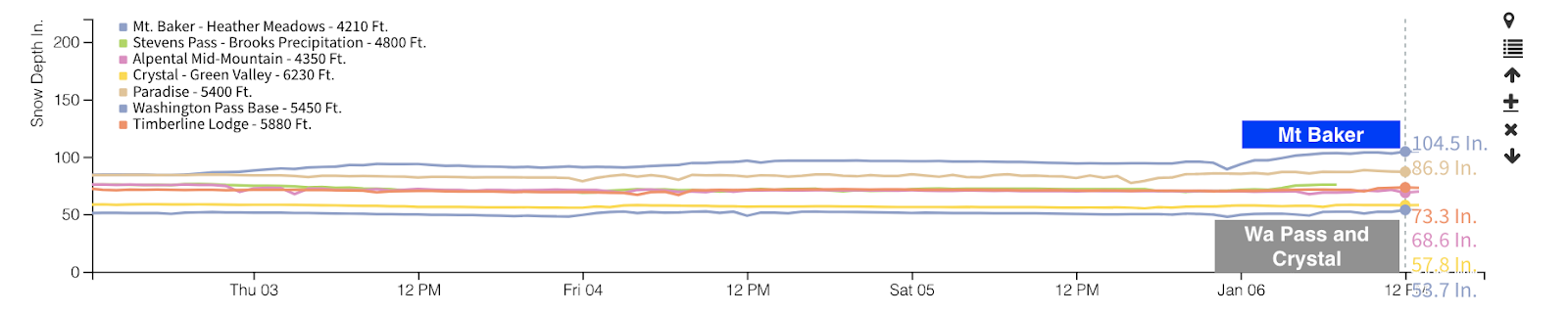
With few exceptions, this season’s storm tracks have favored the North Cascades. Sunday, Mt Baker’s Heather Meadows weather station passed 100 inches of snow on the ground. A quick look around the state’s weather stations demonstrates just how deep this snowpack is. Most other locations are reporting between 50 and 75 inches. The massive amounts of snow for the northern forecast zones are reflected in several impressive avalanche cycles spread out over the last month.
NWAC weather station graph of the height of snow on the ground. Mt Baker passed the 100 inch mark Sunday.
East to West:
Several stacked persistent weak layers have been buried in the eastern forecast zones. This isn’t unusual, but it is noteworthy. The thickness of the slabs over these weak layers can vary greatly. Closer to the Cascade Crest, the deep snowpack may more closely resemble Stevens or Snoqualmie Passes. Further east, shallower snowpacks, and significant variability are keeping snowpack assessment tricky.
Canadian sized surface hoar found buried by 18” of snow in Icicle Creek above Leavenworth on December 31st: Photo by Matt Primomo.
So what now? Well, on January 3 and 4 a high elevation rain event impacted areas from Mt Baker to Mt Hood. In many locations this has created a firm and thickening crust. In these locations, this new crust is limiting the impacts of any deeper weak layers. In locations that didn’t receive as much rain like WA Pass, Mission Ridge, Crystal Mt, and White Pass, how the small amount of rain impacted the mid and lower snowpacks remain to be seen.
Rain and rime crust at 6,500ft above Gallagher Head Lake in the East Central Zone, Jan 5th. This layer was 3 inches thick in this location. Matt Primomo photo.
One thing is for sure, we’re not even a month into the winter season, there’s a lot more winter to come.
Problems
Wind Slabs
You will need to use your eyes and sense of touch to locate wind transported snow as you travel. Look for signs like blowing snow, fresh cornices, and the snow blown out of trees. Feel the snow under you as you travel. Does it feel more firm in one location than another? Does it feel hollow? If you see or feel any of these observations, wind slabs may be nearby. Recent winds formed slabs in some unusual locations like well below ridgelines, on the sides of gullies, and in places that are normally scoured. You can stay safe by traveling on ridges, scoured areas, and any slope less than 35 degrees.
Aspects:
All aspects.
Elevations:
All elevations.
Likelihood
Likely
Expected Size
2 - 2
Persistent Slabs
This snow and wind loading event has stressed older weak layers in some locations. We don’t know yet how these persistent layers responded to the new load. What we do know is we have a weak snowpack structure in some locations and we just put more snow on top of it. Persistent slabs can be difficult to assess and predict. If you see any obvious signs of avalanche danger like recent avalanches, cracks in the snow, or feel sudden collapses, stay away from all slopes greater than 30 degrees.
There are two primary layers of concern in the snowpack. You may encoutner one or both depending on where you travel. You are most like to encounter persistent slab at higher elevations and in areas towards the eastern edge of the forecast zone.
A layer of buried surface hoar may be found 1-2 ft below the snow surface. This layer is mainly a concern above 6000ft.
A layer of weak sugar facets can be found near the ground, particularly in the eastern areas of the forecast zone. If an avalanche failed on this layer, it might be more than 4 feet deep. Use caution if you are traveling in areas where the snowpack is thinner.