

Avalanche forecast

Ogden

Utah Avalanche Center
View on map

Avalanche danger

  • Alpine
  • Treeline
  • Below treeline
Out of date — this forecast expired 7 years ago. You’re viewing past conditions, not the current bulletin.

Highlights

With strong sunshine and warm temperatures, the hazard for wet avalanches may rise to Considerable on aspects facing southeast through west, with a Moderate hazard elsewhere. Activity may involve both loose sluffs as well as larger, wet slab avalanches. Wet avalanche activity will begin much earlier than the past two days, possibly by mid-morning.

Mark will update the Salt Lake City, Ogden and Provo forecasts Saturday morning (April 20th) by 7:30 am.

Avalanche problems

  • Loose Wet

    • Alpine
    • Treeline
    • Below treeline
    Likelihood
    Likely
    Size
    3

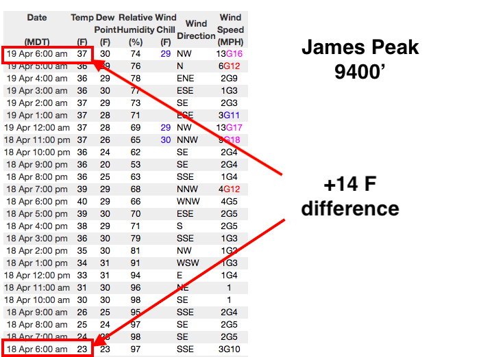
    After two days of strong sunshine and warm temperatures, I think we have gone through much of the wet avalanche cycle that shed the snowfall from earlier this week. But the (1) lack of an overnight refreeze with overnight "lows" +4 to +14 warmer than 24 hours earlier and (2) temperatures that are forecasted to be much warmer than Thursday maintain the risk of wet avalanches today. The past two days wet avalanche activity began by late morning, but I am expecting things to become active much earlier today, including both wet sluffing and possibly much larger wet slabs. The only terrain that may be spared from wet avalanche activity today are northerly aspects above about 8500'.

    Timing is everything! It's time to move off of the snow once the surface becomes soft, wet, and unsupportable.
Special Announcement

The last scheduled forecast will be Sunday, April 21st. We will issue intermittent updates with each snowfall or significant weather event through the rest of the month. We will continue posting observations - so please continue to send those in!

Resorts closed for the season are now backcountry terrain - no avalanche mitigation is being done. Utah ski resorts are on a mix of private and public Forest Service land, and each resort has a different uphill policy - contact the individual resort for details.

Recent Activity

There were no reports from the Ogden backcountry on Thursday. On Wednesday, loose wet avalanches were reported, and were generally above 8,000'.

Snow and Weather

Temperatures this morning in the Ogden mountains range through the 30's and low 40's F. and are +4 to +14 degrees warmer than they were yesterday morning. (Click on this link to see the temperatures at James Peak weather station.)

Wind are blowing from the west and south averaging < 10 mph, with gusts in the teens along upper elevation ridges.

Today's weather features strong sunshine where mountain temperatures will climb well into the 40s F and 50s F, perhaps even pushing 60 F at 8000'. Winds will be out of the southwest and generally light, gusting into the teens and low 20's mph along upper elevation ridgelines.

Although mountain temperatures are above freezing this morning, the clear skies should provide a marginal refreeze of the snow surface at the upper elevations, but it should soften very quickly after sunrise.

General Announcements

CLICK HERE FOR MORE GENERAL INFO AND FAQ

This information does not apply to developed ski areas or highways where avalanche control is normally done. This forecast is from the U.S.D.A. Forest Service, which is solely responsible for its content. This forecast describes general avalanche conditions and local variations always occur.

Regions covered