

Avalanche forecast

Ogden

Utah Avalanche Center
View on map

Avalanche danger

  • Alpine
  • Treeline
  • Below treeline
Out of date — this forecast expired 3 years ago. You’re viewing past conditions, not the current bulletin.

Highlights

The avalanche danger is CONSIDERABLE at the upper elevations on slopes facing northwest through north and southeast. The avalanche danger is MODERATE at the mid elevations and upper elevation aspects facing west and south. There is a LOW avalanche danger at the low elevations.

Avalanche problems

  • Storm Slabs

    • Alpine
    • Treeline
    • Below treeline
    Likelihood
    Likely
    Size
    2

    The new snow will be reactive today, especially during any period of heavy snowfall. Gusty northwest winds may also create sensitive soft slabs along exposed ridges at the mid and upper elevations.

    Watch for signs of cracking or sluffing in the new snow as indication of sensitive conditions.

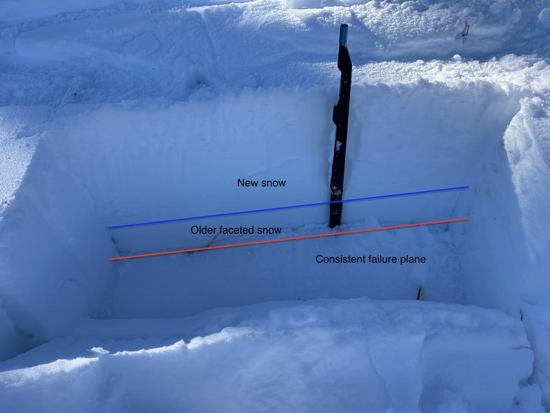
    Avalanches in the storm snow will be 6-12" deep, although they may break down several feet deep on northerly-facing slopes where there is a buried persistent weak layer. Read more below.

  • Persistent Slabs

    • Alpine
    • Treeline
    • Below treeline
    Likelihood
    Likely
    Size
    3

    The base of the snowpack on upper elevation slopes facing west/north/east consists of weak, faceted snow.

    Although this weak layer has become less sensitive, recent wind-loading and snowfall today will further stress this buried weak layer. Any avalanche that fails on this weak layer will be 2-4' deep and over a hundred feet wide. I continue to avoid being on, underneath, or adjacent to slopes 30 degrees or steeper on aspects where this persistent weak layer is present.

    Drew Hardesty investigating an avalanche that failed on a buried PWL from his field day on Monday on Cutler Ridge with Zach Little

Recent Activity

No avalanche activity was reported from the backcountry on Thursday. Two recent observations:

UAC forecasters Mark Staples and Dave Kelly were on Bountiful Peak on Thursday.

Richie Schumacher was in Upper Pine Creek on Wednesday.

Snow and Weather

This Morning: As of 6 am, 4-6" of snow has fallen in the Ogden mountains with 24-hour snow totals of 8". Temperatures are a few degrees on either side of 15° F and winds are from the west/northwest, averaging in the teens with gusts in the 20's and 30's mph along exposed mid and upper elevation ridgelines.

Today: A Winter Storm Warning has been issued for the Wasatch Mountains through 11 pm tonight, with periods of heavy snow on a cold, northwest flow, delivering 4-8" by nightfall. Temperatures will be in the teens and low 20's F and the gusty northwest winds will average in the teens and 20's mph with gusts into the 30's mph along exposed mid and upper elevation ridgelines.

This Weekend: We'll squeeze out a few additional inches of snow overnight, and the weekend will feature cool temperatures, partly-sunny skies, and light to moderate winds from the west/northwest.

General Announcements

CLICK HERE FOR MORE GENERAL INFO AND FAQ

This information does not apply to developed ski areas or highways where avalanche control is normally done. This forecast is from the U.S.D.A. Forest Service, which is solely responsible for its content. This forecast describes general avalanche conditions and local variations always occur.

Regions covered