
Quick report
Main objective was to investigate the persistent weak layers and snowpack structure East of the CD where temperatures are generally colder with less snowfall (and therefore weaker). To my surprise the snowpack was fairly deep, around 150cm (60"). The snowpack on on northerlies has remained dry during the slight spring transition. Persistent weak layers (PWL) could still be a concern where there is a deeper snowpack on northerly aspects in the middle elevations. PWLs in the upper elevations remain more widespread (See snow profiles from Noah at Angle Mountain.
I found generally stable conditions in the top portion of the snowpack today. Old wind slabs are likely stubborn due to large diurnal temperature fluctations. Snow surfaces varied from preserved powder on north (no near surface facets or surface hoar observed) to firm crusts on south and lots of wind packed snow on open and exposed terrain. New snow coming in tomorrow will fall on a variety of surfaces and bond differently. Forecasted snow totals remain low Thurs-Fri on Togwotee.
Snowpack
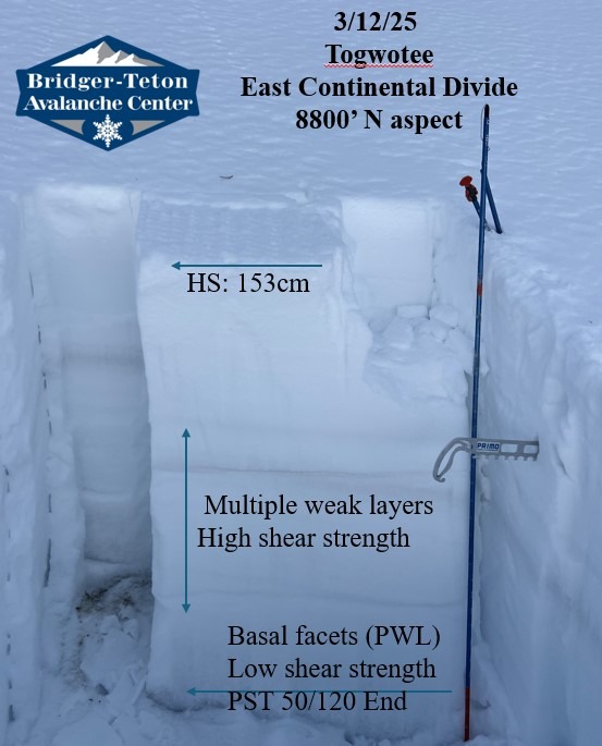
Deeper snowpack exists on N-W-E aspects. Found poor structure with relatively high strength. Extended column stability tests did not produce any propagation. This could be due to the depth and hardness of the overlying slab. During the shovel shear the entire column failed on the basal facets formed in December and did not fail on any weak layers formed Jan or Feb. The top half of the snowpack is gaining strength. One propagation saw test on a N aspect produced more stable results on basal facets than expected.
8800' N aspect HS: 153cm ECTX PST50/120 on dry basal facets 30cm from the ground.
8800' W aspect (shaded) HS: 144cm ECTX. The whole snowpack was slightly wetter than N aspect. Wouldn't consider the basal facets completely moist.
Southerly aspects held less than 100cm of snow. Significant free water movement has occured on southerly aspects with wet snow to the ground and percolation columns. A deep freeze will lock up the snowpack in middle elevations. This may not be the case on southerlies quite yet.